
Original file (3,160 × 2,547 pixels, file size: 6.69 MB, MIME type: image/jpeg)
| This is a file from the
Wikimedia Commons. Information from its
description page there is shown below. Commons is a freely licensed media file repository. You can help. |
Summary
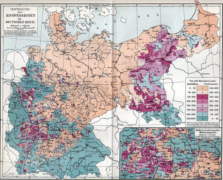
| Description | Map showing distribution of Catholics and Protestants in the German Reich as of the 1890s. For a full discussion of this map, including detailed statistics, from the original source (and written in German), see the talk page. |
| Date | 1893–97 |
| Source | Map owned and scanned by Angr |
| Author | Meyers Konversationslexikon, 5th edition |
| Permission ( Reusing this file) |
Public domain |
Licensing
|
This work is in the public domain in its country of origin and other countries and areas where the copyright term is the author's life plus 70 years or fewer.
| |
| This file has been identified as being free of known restrictions under copyright law, including all related and neighboring rights. | |
File history
Click on a date/time to view the file as it appeared at that time.
| Date/Time | Thumbnail | Dimensions | User | Comment | |
|---|---|---|---|---|---|
| current | 04:39, 7 February 2014 |
| 3,160 × 2,547 (6.69 MB) | DIREKTOR | Crop & tone |
| 06:49, 1 December 2007 |
 | 3,512 × 2,553 (1.43 MB) | Mahagaja | {{Information |Description=Map showing distribution of Catholics and Protestants in the German Reich as of the 1890s |Source=Map owned and scanned by Angr |Date=1893–97 |Author=Meyers Konversationslexikon, 5th edition |Permission=Public do |
File usage
Global file usage
The following other wikis use this file:
- Usage on ar.wikipedia.org
- Usage on azb.wikipedia.org
- Usage on da.wikipedia.org
- Usage on de.wikipedia.org
- Usage on el.wikipedia.org
- Usage on fr.wikipedia.org
- Usage on hr.wikipedia.org
- Usage on it.wikipedia.org
- Usage on ko.wikipedia.org
- Usage on mt.wikipedia.org
- Usage on pl.wikipedia.org
- Usage on pt.wikipedia.org
- Usage on zh.wikipedia.org