PhotosLocation

This is a file from the Wikimedia Commons
From Wikipedia, the free encyclopedia

Original file(9,658 × 7,584 pixels, file size: 3.59 MB, MIME type: image/png)

This image is a JPEG version of the original TIF image at File: Vandergrift-Biddle House, Junction of US Route 13 and County Road 2, Saint Georges Hundred, Biddles Corner, New Castle County, DE HABS DEL,2-BIDCO,1- (sheet 1 of 8).tif.

However, any edits to the image should be based on the original TIF version in order to prevent generation loss, and both versions should be updated. Do not make edits based on this version.

Summary

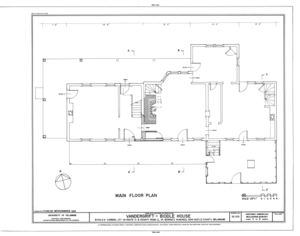
HABS DEL,2-BIDCO,1- (sheet 1 of 8) - Vandergrift-Biddle House, Junction of US Route 13 and County Road 2, Saint Georges Hundred, Biddles Corner, New Castle County, DE
Title
HABS DEL,2-BIDCO,1- (sheet 1 of 8) - Vandergrift-Biddle House, Junction of US Route 13 and County Road 2, Saint Georges Hundred, Biddles Corner, New Castle County, DE
Depicted place Delaware; New Castle County; Biddles Corner
Date Documentation compiled after 1933
Dimensions 19 x 24 in. (B size)
Current location
Library of Congress Prints and Photographs Division Washington, D.C. 20540 USA http://hdl.loc.gov/loc.pnp/pp.print
Accession number
HABS DEL,2-BIDCO,1- (sheet 1 of 8)
Credit line
This file comes from the Historic American Buildings Survey (HABS), Historic American Engineering Record (HAER) or Historic American Landscapes Survey (HALS). These are programs of the National Park Service established for the purpose of documenting historic places. Records consist of measured drawings, archival photographs, and written reports.

This tag does not indicate the copyright status of the attached work. A normal copyright tag is still required. See Commons:Licensing.

Notes
  • Significance: Begun by the Vandergrift family in the mid-eighteenth century as a one-story, hall-plan dwelling and repeatedly enlarged through the nineteenth century by the Biddle family and others, the Vandergrift-Biddle House is significant for the changes in house form and timber-building technology in its long and complicated history. With its seven major building periods, using a variety of construction techniques including joined plank, braced frame (mortise and tenoned post and beam), and balloon frame, the Vandergrift-Biddle House has achieved both architectural significance and integrity by the process of historic accretion. For instance, the sequence of alterations in the hall hearth clearly demonstrates changing social attitudes toward cleanliness and comfort; the firebox was closed down repeatedly to provide ever more heat, while at the same time, further containing dirt and smoke. Successive generations of the Vandergrift and Biddle families also incorporated modern concepts in the plan, but never strayed from traditional patterns of architectural logic. In each period of its growth the house was rebuilt as a new and larger structure; increasingly unified on the exterior, but retaining much of its earlier fabric. The Vandergrift-Biddle House was listed on the National Register of Historic Places in December, 1978.
  • Unprocessed Field note material exists for this structure: FN-45
  • Survey number: HABS DE-224
  • Building/structure dates: ca. 1750 Initial Construction
  • Building/structure dates: ca. 1800 Subsequent Work
  • Building/structure dates: ca. 1830 Subsequent Work
  • Building/structure dates: ca. 1840 Subsequent Work
  • Building/structure dates: ca. 1870 Subsequent Work
  • Building/structure dates: ca. 1890 Subsequent Work
References

This is an image of a place or building that is listed on the National Register of Historic Places in the United States of America. Its reference number is 78000908.

Source https://www.loc.gov/pictures/item/de0322.sheet.00001a
Permission
( Reusing this file)
Public domain This image or media file contains material based on a work of a National Park Service employee, created as part of that person's official duties. As a work of the U.S. federal government, such work is in the public domain in the United States. See the NPS website and NPS copyright policy for more information.
Other versions
Camera location 39° 31′ 30″ N, 75° 38′ 57.98″ W  Kartographer map based on OpenStreetMap.View this and other nearby images on: OpenStreetMap info

Information (Geography)

Captions

Add a one-line explanation of what this file represents

Items portrayed in this file

depicts

39°31'30"N, 75°38'56"W

File history

Click on a date/time to view the file as it appeared at that time.

Date/TimeThumbnailDimensionsUserComment
current 19:00, 20 July 2014 Thumbnail for version as of 19:00, 20 July 20149,658 × 7,584 (3.59 MB){{Compressed version|file=File:Vandergrift-Biddle_House,_Junction_of_US_Route_13_and_County_Road_2,_Saint_Georges_Hundred,_Biddles_Corner,_New_Castle_County,_DE_HABS_DEL,2-BIDCO,1-_(sheet_1_of_8).tif|thumb=nothumb}} =={{int:filedesc}}== {{Photograph...
The following pages on the English Wikipedia use this file (pages on other projects are not listed):

Global file usage

The following other wikis use this file:

Metadata