Size of this preview:
598 × 600 pixels. Other resolutions:
239 × 240 pixels |
479 × 480 pixels |
765 × 767 pixels.
Original file (765 × 767 pixels, file size: 230 KB, MIME type: image/jpeg)
| This is a file from the
Wikimedia Commons. Information from its
description page there is shown below. Commons is a freely licensed media file repository. You can help. |
Summary
| Description |
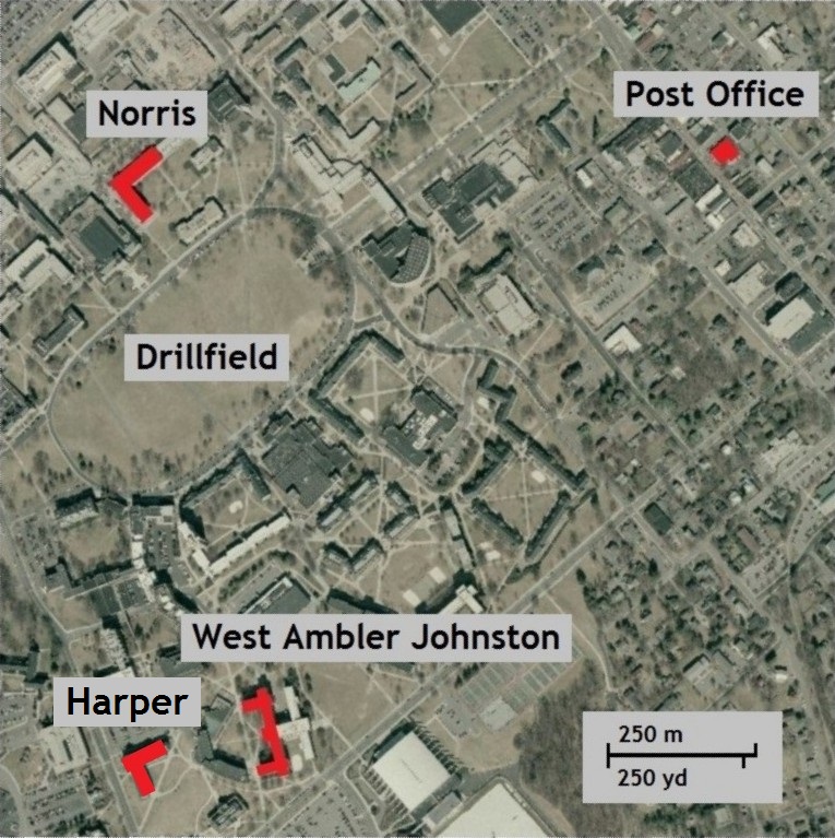
English: Map of Virginia Tech campus and downtown Blacksburg, VA, with Norris Hall, West Ambler Johnston Hall, and the U.S. Post Office shown in red, with labels. Base map from TerraServer (USGS). |
||
| Date | |||
| Source | USGS TerraServer map edited to highlight locations on VA Tech campus and in Blacksburg, VA. From the USGS Abstract: "These files contain Digital Orthophoto files for the State of Virginia developed from imagery acquired in spring 2006 and 2007." | ||
| Author | D'Ranged 1 | ||
| Permission ( Reusing this file) |
|
||
| Other versions | File:Norris WestAJ Map scale.jpg; File:Norris_WestAJ_Map.jpg (This version includes the U.S. Post Office in Blacksburg, VA, and corrects the spelling of "Drillfield" to one word. I created this using original maps from the USGS, not the previous versions.) |
Licensing
I, the copyright holder of this work, hereby publish it under the following license:
| This file is made available under the Creative Commons CC0 1.0 Universal Public Domain Dedication. | |
| The person who associated a work with this deed has dedicated the work to the
public domain by waiving all of their rights to the work worldwide under copyright law, including all related and neighboring rights, to the extent allowed by law. You can copy, modify, distribute and perform the work, even for commercial purposes, all without asking permission.
|
This image is in the
public domain in the United States because it only contains materials that originally came from the
United States Geological Survey, an agency of the
United States Department of the Interior. For more information, see
the official USGS copyright policy.
|
File history
Click on a date/time to view the file as it appeared at that time.
| Date/Time | Thumbnail | Dimensions | User | Comment | |
|---|---|---|---|---|---|
| current | 13:39, 31 May 2014 |
| 765 × 767 (230 KB) | D'Ranged 1 | Added red highlighting for Harper Hall, Cho's dormitory |
| 15:51, 23 May 2014 |
 | 767 × 767 (266 KB) | D'Ranged 1 | Category:Virginia Tech massacre | |
| 15:24, 23 May 2014 |
 | 767 × 767 (266 KB) | D'Ranged 1 | User created page with UploadWizard |
File usage
The following pages on the English Wikipedia use this file (pages on other projects are not listed):
Global file usage
The following other wikis use this file:
- Usage on zh.wikipedia.org