Size of this PNG preview of this TIF file:
800 × 509 pixels. Other resolutions:
320 × 203 pixels |
640 × 407 pixels |
1,024 × 651 pixels |
1,280 × 814 pixels |
2,560 × 1,628 pixels |
3,586 × 2,280 pixels.
Original file (3,586 × 2,280 pixels, file size: 8.78 MB, MIME type: image/tiff)
| This is a file from the
Wikimedia Commons. Information from its
description page there is shown below. Commons is a freely licensed media file repository. You can help. |
Summary
| Description |
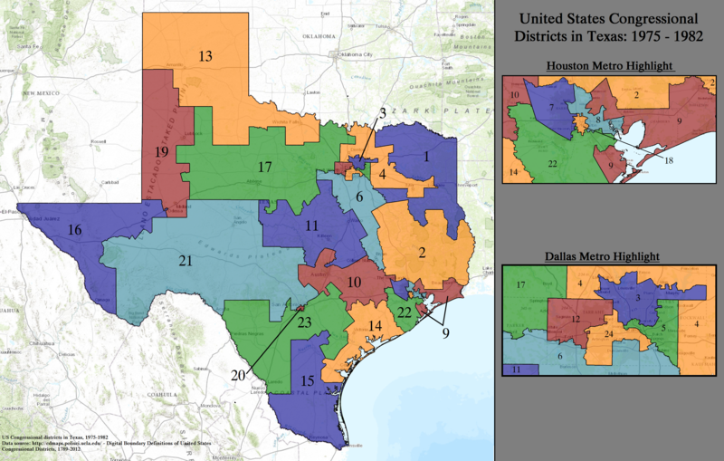
English: Statewide boundaries map for United States congressional districts in Texas, 1975–1982. |
| Date | |
| Source | US Department of the Interior, public data retrieved and rendered from archive at: http://cdmaps.polisci.ucla.edu on October 18, 2014. |
| Author | Authors: 1) All GIS data presented in this project was originally collected and published by the United States Department of the Interior. 2) US district GIS shapefile data created in association with the UCLA by Jeffrey B. Lewis, Brandon DeVine, Lincoln Pitcher, and Kenneth C. Martis. (2013) Digital Boundary Definitions of United States Congressional Districts, 1789-2012. 3) Data was rendered using ArcGIS® software by Esri. 4) File developed for use on Wikipedia and elsewhere by 7partparadigm. |
Licensing
| This image or media file contains material based on a work of a United States Department of the Interior employee, created as part of that person's official duties. As a work of the U.S. federal government, such work is in the public domain in the United States. See the Department of the Interior copyright policy for more information. |  |
File history
Click on a date/time to view the file as it appeared at that time.
| Date/Time | Thumbnail | Dimensions | User | Comment | |
|---|---|---|---|---|---|
| current | 04:05, 27 May 2015 |
 | 3,586 × 2,280 (8.78 MB) | 7partparadigm | User created page with UploadWizard |
File usage
The following pages on the English Wikipedia use this file (pages on other projects are not listed):