No higher resolution available.
United_States_1860-1870.gif (787 × 483 pixels, file size: 49 KB, MIME type: image/gif, looped, 28 frames, 35 s)
| This is a file from the
Wikimedia Commons. Information from its
description page there is shown below. Commons is a freely licensed media file repository. You can help. |
Summary
| Description |
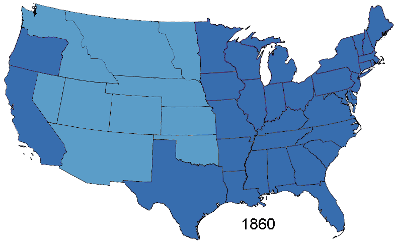
English: Animated map, about the American Civil War and the restoration of the southern states and the Union (made in Photoshop).
States of the Union (with full delegations in the U.S. Congress)
Union Territories (including the southern states before and during the war)
States of the Confederacy
Territories of the Confederacy |
| Source | Based on Creative Commons Licenced 1861 map and GNU-1864 Licenced map. Information from the Wikipedia articles Confederate States of America, List of US states by date of statehood, and has also just exterior sites When states Became states. Civil war borders Used from public domain Perry-Castañeda Library Map Collection 1861-1865 map. Border Between Arizona Territory (CSA) and New Mexico Territory Is That Depicted in public domain map Image: Map of CSA 4.png |
| Author | User:Roke~commonswiki |
Licensing
As the maps this was based on were licenced as GFDL and creative commons (not including the public domain maps), this is licenced under both licences.

|
Permission is granted to copy, distribute and/or modify this document under the terms of the GNU Free Documentation License, Version 1.2 or any later version published by the Free Software Foundation; with no Invariant Sections, no Front-Cover Texts, and no Back-Cover Texts. A copy of the license is included in the section entitled GNU Free Documentation License. |
| This file is licensed under the Creative Commons Attribution-Share Alike 3.0 Unported license. | ||
| ||
| This licensing tag was added to this file as part of the GFDL licensing update. |
This file is licensed under the
Creative Commons
Attribution-Share Alike 2.5 Generic license.
- You are free:
- to share – to copy, distribute and transmit the work
- to remix – to adapt the work
- Under the following conditions:
- attribution – You must give appropriate credit, provide a link to the license, and indicate if changes were made. You may do so in any reasonable manner, but not in any way that suggests the licensor endorses you or your use.
- share alike – If you remix, transform, or build upon the material, you must distribute your contributions under the same or compatible license as the original.
File history
Click on a date/time to view the file as it appeared at that time.
| Date/Time | Thumbnail | Dimensions | User | Comment | |
|---|---|---|---|---|---|
| current | 14:02, 2 January 2015 |
| 787 × 483 (49 KB) | Sapph | Fixed incorrect succession order of North Carolina and Tennessee by swapping frames 10 and 11. |
| 05:00, 2 August 2006 |
 | 787 × 483 (49 KB) | Roke~commonswiki | Animated map showing Confederacy, American Civil War and re-admission of southern states to the Union, made in Photoshop. {{legend|#376dae|States of the Union}} {{legend|#5b9dc8|Territories of the Union (including occupied territory during and after the |
File usage
The following pages on the English Wikipedia use this file (pages on other projects are not listed):
- Historical regions of the United States
- History of the Southern United States
- Talk:United States/Archive 36
- Wikipedia:Featured picture candidates/CSA states evolution.gif
- Wikipedia:Featured picture candidates/March-2007
- Portal:American Civil War/Intro/images
- Portal:American Civil War/Intro/images/rotation/41
Global file usage
The following other wikis use this file:
- Usage on af.wikipedia.org
- Usage on ar.wikipedia.org
- Usage on bn.wikipedia.org
- Usage on ca.wikipedia.org
- Usage on cs.wikipedia.org
- Usage on es.wikipedia.org
- Usage on eu.wikipedia.org
- Usage on fa.wikipedia.org
- Usage on fr.wikipedia.org
- Usage on it.wikipedia.org
- Usage on ja.wikipedia.org
- Usage on lt.wikipedia.org
- Usage on ms.wikipedia.org
- Usage on pt.wikipedia.org
- Usage on www.wikidata.org