No higher resolution available.
UTMap-doton-EscalanteRiver.png (153 × 200 pixels, file size: 1 KB, MIME type: image/png)
| This is a file from the
Wikimedia Commons. Information from its
description page there is shown below. Commons is a freely licensed media file repository. You can help. |
Summary
| Description | |
| Date | 12 April 2007 (original upload date) |
| Source | Transferred from en.wikipedia to Commons. |
| Author | G. Thomas at English Wikipedia |
Licensing
| This work has been released into the
public domain by its author,
G. Thomas at
English Wikipedia. This applies worldwide. In some countries this may not be legally possible; if so: G. Thomas grants anyone the right to use this work for any purpose, without any conditions, unless such conditions are required by law. |
Original upload log
The original description page was
here. All following user names refer to en.wikipedia.
| Date/Time | Dimensions | User | Comment |
|---|---|---|---|
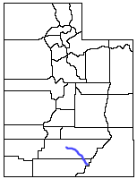
| 2007-10-10 19:57 | 153×200× (1287 bytes) | G. Thomas | Location of the [[Escalante River]] within [[Utah]]. |
| 2007-04-12 20:42 | 153×200× (1177 bytes) | G. Thomas | Location of the [[Escalante River]] within [[Utah]]. |
File history
Click on a date/time to view the file as it appeared at that time.
| Date/Time | Thumbnail | Dimensions | User | Comment | |
|---|---|---|---|---|---|
| current | 22:02, 27 August 2014 |
| 153 × 200 (1 KB) | Ixfd64 | Transferred from en.wikipedia |
File usage
No pages on the English Wikipedia use this file (pages on other projects are not listed).