Size of this preview:
800 × 562 pixels. Other resolutions:
320 × 225 pixels |
640 × 449 pixels |
1,024 × 719 pixels |
1,280 × 899 pixels |
1,995 × 1,401 pixels.
Original file (1,995 × 1,401 pixels, file size: 1.11 MB, MIME type: image/jpeg)
| This is a file from the
Wikimedia Commons. Information from its
description page there is shown below. Commons is a freely licensed media file repository. You can help. |
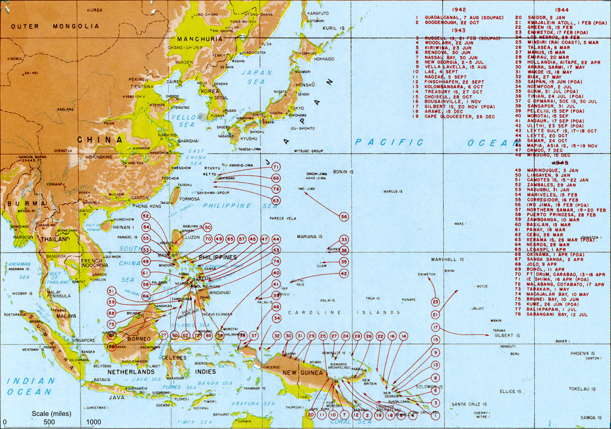
| Description | Map titled "Allied landings — August 1942 to August 1945", plate #126. It should be noted that while the title of the image is "US Landings" the map also indicates the position of many landings by Australian troops (at least) so should be referred to as "Allied landings". | |||
| Date | circa 1950 | |||
| Source | MacArthur, Douglas (1994) [1950] Reports of General MacArthur, Vol. 1, Center of Military History, pp. p. 432. Archived from the original on 12 February 2009. Retrieved on 24 February 2009. | |||
| Author | General MacArthur's General Staff | |||
| Permission ( Reusing this file) |
|
|||
| Other versions |
Derivative works of this file: US landings saipan.jpg
|


Transfer log
- Transfered from Wikipedia image of same name. Text above copied from Wikipedia. Performed by Mak 21:58, 29 May 2006 (UTC)
File history
Click on a date/time to view the file as it appeared at that time.
| Date/Time | Thumbnail | Dimensions | User | Comment | |
|---|---|---|---|---|---|
| current | 18:51, 21 February 2010 |
| 1,995 × 1,401 (1.11 MB) | Raul654 | Added scale to map (using Darwin-Makassar distance as 925 miles, per web sources) |
| 05:31, 24 February 2009 |
 | 1,995 × 1,401 (1.37 MB) | Jappalang | Clearer map taken from the US Army site | |
| 21:58, 29 May 2006 |
 | 2,000 × 1,363 (437 KB) | Makthorpe | Allied landings - August 1942 to August 1945 Source: Scanned from Reports of General MacArthur (1994 facsimile printing), Vol 1. Plate #126 Category:World War II (pacific) Category: WWII maps (Pacific) License: Official US government document - |
File usage
The following pages on the English Wikipedia use this file (pages on other projects are not listed):
Global file usage
The following other wikis use this file:
- Usage on ar.wikipedia.org
- Usage on ast.wikipedia.org
- Usage on azb.wikipedia.org
- Usage on az.wikipedia.org
- Usage on bg.wikipedia.org
- Usage on bjn.wikipedia.org
- Usage on br.wikipedia.org
- Usage on bs.wikipedia.org
- Usage on ca.wikipedia.org
- Usage on cs.wikipedia.org
- Usage on da.wikipedia.org
- Usage on el.wikipedia.org
- Usage on es.wikipedia.org
- Usage on et.wikipedia.org
- Usage on eu.wikipedia.org
- Usage on fa.wikipedia.org
- Usage on fi.wikipedia.org
- Usage on fr.wikipedia.org
- Seconde Guerre mondiale
- Discussion:Guerre du Pacifique
- Discussion utilisateur:Archeos/Discussions de salle de rédaction
- Discussion Projet:Seconde Guerre mondiale/Archive 2006
- Discussion utilisateur:Lilliputien/Renseignements généraux/RAZ
- Discussion Projet:Histoire militaire/Archive 2006
- Utilisateur:Pontauxchats/Archives Pontauxchats 9
- Discussion utilisateur:L'amateur d'aéroplanes/Archive1
- Discussion Projet:Seconde Guerre mondiale/Archive 1
- Capitulation du Japon
- Usage on ha.wikipedia.org
- Usage on he.wikipedia.org
- Usage on hr.wikipedia.org
- Usage on hu.wikipedia.org
- Usage on hy.wikipedia.org
- Usage on id.wikipedia.org
- Usage on it.wikipedia.org
- Usage on ka.wikipedia.org
- Usage on lt.wikipedia.org
- Usage on ml.wikipedia.org
- Usage on ms.wikipedia.org
- Usage on nl.wikipedia.org
View more global usage of this file.