
Size of this preview:
800 × 520 pixels. Other resolutions:
320 × 208 pixels |
640 × 416 pixels |
1,024 × 665 pixels |
1,513 × 983 pixels.
Original file (1,513 × 983 pixels, file size: 46 KB, MIME type: image/png)
| This is a file from the
Wikimedia Commons. Information from its
description page there is shown below. Commons is a freely licensed media file repository. You can help. |
Summary
| Description |
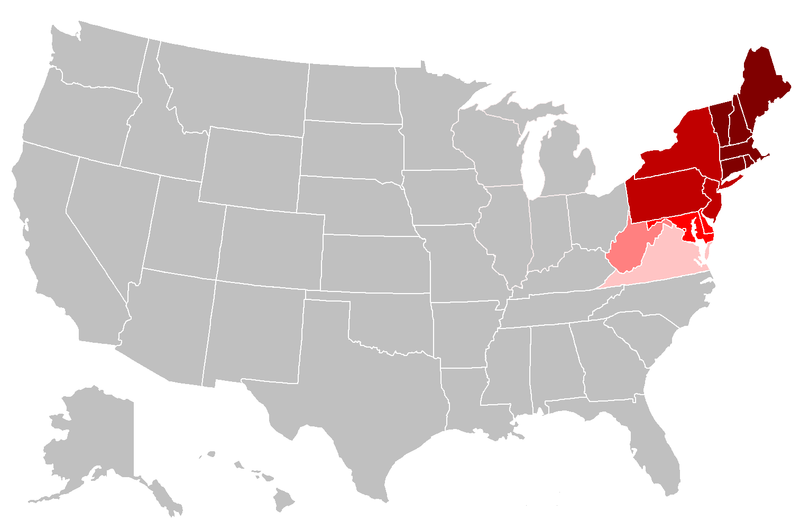
English: Map of the northeastern United States. The pink areas include states that are cited by fewer reliable sources as being included in the Northeast. The red areas are more frequently cited by reliable sources, and the dark red are the most commonly accepted as being included in the Northeast. |
| Date | |
| Source | Own work, File:BlankMap-USA-states.PNG |
| Author | Grayshi, Roke, Maher-shalal-hashbaz |
Licensing
I, the copyright holder of this work, hereby publish it under the following licenses:
This file is licensed under the
Creative Commons
Attribution-Share Alike 3.0 Unported license.
- You are free:
- to share – to copy, distribute and transmit the work
- to remix – to adapt the work
- Under the following conditions:
- attribution – You must give appropriate credit, provide a link to the license, and indicate if changes were made. You may do so in any reasonable manner, but not in any way that suggests the licensor endorses you or your use.
- share alike – If you remix, transform, or build upon the material, you must distribute your contributions under the same or compatible license as the original.

|
Permission is granted to copy, distribute and/or modify this document under the terms of the GNU Free Documentation License, Version 1.2 or any later version published by the Free Software Foundation; with no Invariant Sections, no Front-Cover Texts, and no Back-Cover Texts. A copy of the license is included in the section entitled GNU Free Documentation License. |
You may select the license of your choice.
File history
Click on a date/time to view the file as it appeared at that time.
| Date/Time | Thumbnail | Dimensions | User | Comment | |
|---|---|---|---|---|---|
| current | 23:19, 25 April 2018 |
| 1,513 × 983 (46 KB) | Swarm | The Bureau of Prisons by itself is not sufficient to support Ohio being geographically classified as NE |
| 19:39, 6 February 2016 |
 | 1,513 × 983 (31 KB) | Hoppingalong | Mean to revert back to this map by Maher-shalal-hashbaz | |
| 19:38, 6 February 2016 |
 | 1,513 × 983 (36 KB) | Hoppingalong | Reverted to version as of 21:29, 5 May 2014 (UTC) - This is consistent with the article it illustrates. | |
| 03:54, 15 August 2015 |
 | 1,513 × 983 (46 KB) | Swarm | Removing Midwestern states. The source behind the inclusion and the weight given to the concept of these states being "Northeastern" are dubious at best and contradict the general body of reliable sources. | |
| 21:56, 5 May 2014 |
 | 1,513 × 983 (36 KB) | KenHigh | I keep trying to upload a new version and the new version appears in wiki properly, but when I upload it wiki shows the old version. The new version shows Wisconsin, Illinois, Michigan and Indiana in light pink, but when I upload it it shows them in gr... | |
| 21:32, 5 May 2014 |
 | 1,513 × 983 (36 KB) | KenHigh | Added new version of map showing Wisconsin, Illinois, Michigan and Indiana as states which are sometimes included in alternative definitions of the Northeast as stated and referenced in other parts of the article. | |
| 21:29, 5 May 2014 |
 | 1,513 × 983 (36 KB) | KenHigh | Added Wisconsin, Michigan, Illinois and Indiana in light pink to indicate that these states are also sometimes included in definitions of the Northeast as stated and referneced by other sections of this article. | |
| 14:55, 25 September 2013 |
 | 1,513 × 983 (31 KB) | Maher-shalal-hashbaz | Added differentiation between states that are more commonly cited as Northeastern by reliable sources, and those which are less commonly cited as Northeastern by reliable sources. | |
| 23:23, 13 March 2010 |
 | 1,513 × 983 (43 KB) | Grayshi | fix red glow | |
| 23:20, 13 March 2010 |
 | 1,513 × 983 (69 KB) | Grayshi | cut the dark red boundary to be slightly more northern |
File usage
The following pages on the English Wikipedia use this file (pages on other projects are not listed):
Global file usage
The following other wikis use this file:
- Usage on ar.wikipedia.org
- Usage on ckb.wikipedia.org
- Usage on fa.wikipedia.org
- Usage on it.wikipedia.org
- Usage on nl.wikipedia.org
- Usage on ur.wikipedia.org