No higher resolution available.
US_31_in_1936.png (757 × 467 pixels, file size: 637 KB, MIME type: image/png)
| This is a file from the
Wikimedia Commons. Information from its
description page there is shown below. Commons is a freely licensed media file repository. You can help. |
Summary
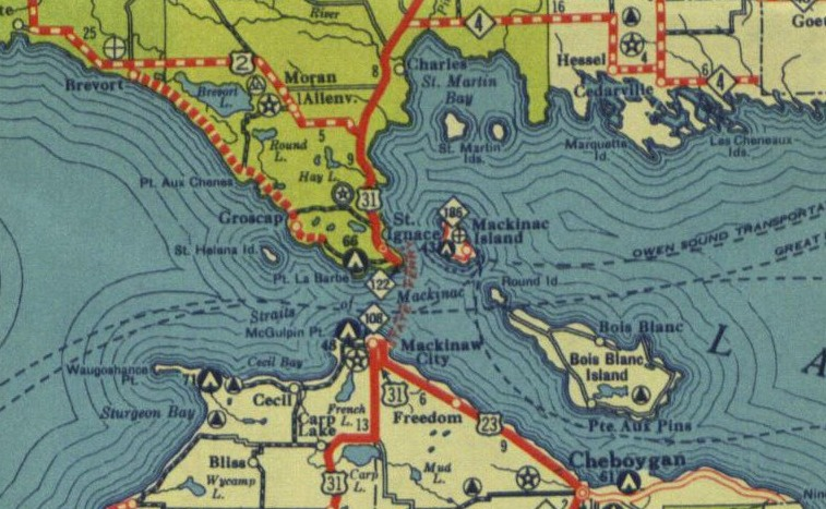
| Description |
English: A section of the June 1936 state highway map showing US 31 in the Upper Peninsula of Michigan |
| Date | |
| Source | Michigan State Highway Department |
| Author | MSHD |
| Permission ( Reusing this file) |
State maps were not copyright protected until 1958 according to MDOT MDOT - Key Dates in Map History |
Licensing
This work is in the
public domain in the United States because it was
published in the United States between 1929 and 1977, inclusive, without a
copyright notice. For further explanation, see
Commons:Hirtle chart as well as a
detailed definition of "publication" for public art. Note that it may still be copyrighted in jurisdictions that do not apply the
rule of the shorter term for US works (depending on the date of the author's death), such as Canada (50
p.m.a.), Mainland China (50 p.m.a., not Hong Kong or Macao), Germany (70 p.m.a.), Mexico (100 p.m.a.), Switzerland (70 p.m.a.), and other countries with individual treaties.
|
 |
File history
Click on a date/time to view the file as it appeared at that time.
| Date/Time | Thumbnail | Dimensions | User | Comment | |
|---|---|---|---|---|---|
| current | 04:43, 14 April 2014 |
| 757 × 467 (637 KB) | Imzadi1979 | User created page with UploadWizard |
File usage
The following pages on the English Wikipedia use this file (pages on other projects are not listed):