Size of this preview:
476 × 600 pixels. Other resolutions:
190 × 240 pixels |
381 × 480 pixels |
872 × 1,099 pixels.
Original file (872 × 1,099 pixels, file size: 217 KB, MIME type: image/png)
| This is a file from the
Wikimedia Commons. Information from its
description page there is shown below. Commons is a freely licensed media file repository. You can help. |
Summary
| Description |
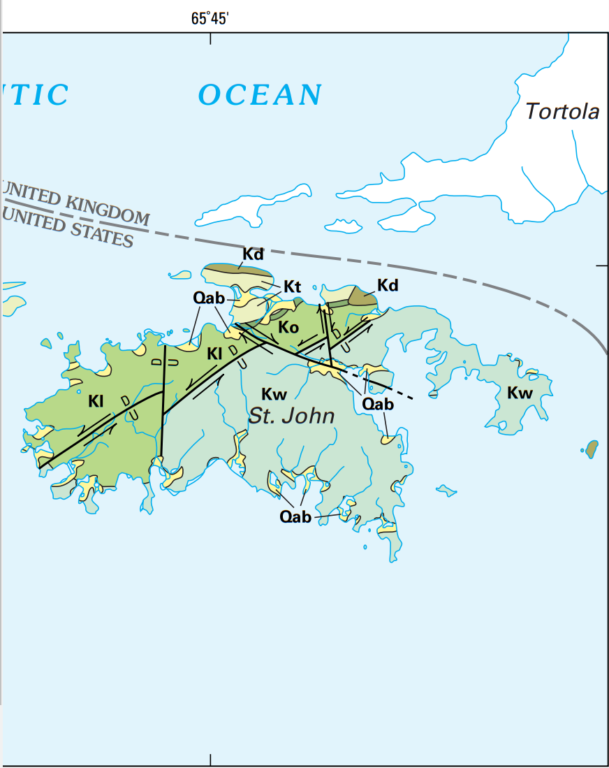
English: USGS geologic map St John USVI, where Qab is Quaternary alluvium and minor beach deposits, Kt is the Cretaceous Tutu Formation, Ko is the Cretaceous Outer Brass Formation, Kl is the Cretaceous Lousenhoj Formation, Kw is the Water Island Formation, and Kd are Cretaceous dioritic rocks, while U and D show the upthrown and downthrown portion of faults. |
| Date | |
| Source |
Geology and Hydrogeology of the Caribbean Islands Aquifer System of the Commonwealth of Puerto Rico and the U.S. Virgin Islands, USGS Professional Paper 1419, https://pubs.usgs.gov/pp/pp1419/pdf/BOOK.PDF |
| Author | ROBERT A. RENKEN, W.C. WARD, I.P. GILL, FERNANDO GÓMEZ-GÓMEZ, JESÚS RODRÍGUEZ-MARTÍNEZ |
Licensing
This image is in the
public domain in the United States because it only contains materials that originally came from the
United States Geological Survey, an agency of the
United States Department of the Interior. For more information, see
the official USGS copyright policy.
|
File history
Click on a date/time to view the file as it appeared at that time.
| Date/Time | Thumbnail | Dimensions | User | Comment | |
|---|---|---|---|---|---|
| current | 10:30, 5 March 2019 |
| 872 × 1,099 (217 KB) | Pi3.124 | User created page with UploadWizard |
File usage
The following pages on the English Wikipedia use this file (pages on other projects are not listed):
Global file usage
The following other wikis use this file:
- Usage on www.wikidata.org