
Size of this preview:
776 × 600 pixels. Other resolutions:
311 × 240 pixels |
621 × 480 pixels |
994 × 768 pixels |
1,280 × 989 pixels |
2,560 × 1,978 pixels |
3,300 × 2,550 pixels.
Original file (3,300 × 2,550 pixels, file size: 3.98 MB, MIME type: image/jpeg)
| This is a file from the
Wikimedia Commons. Information from its
description page there is shown below. Commons is a freely licensed media file repository. You can help. |
Summary
| Description |
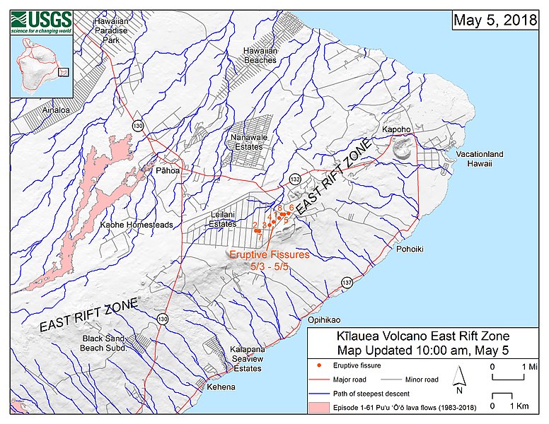
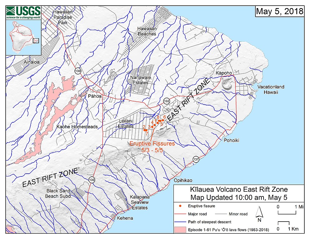
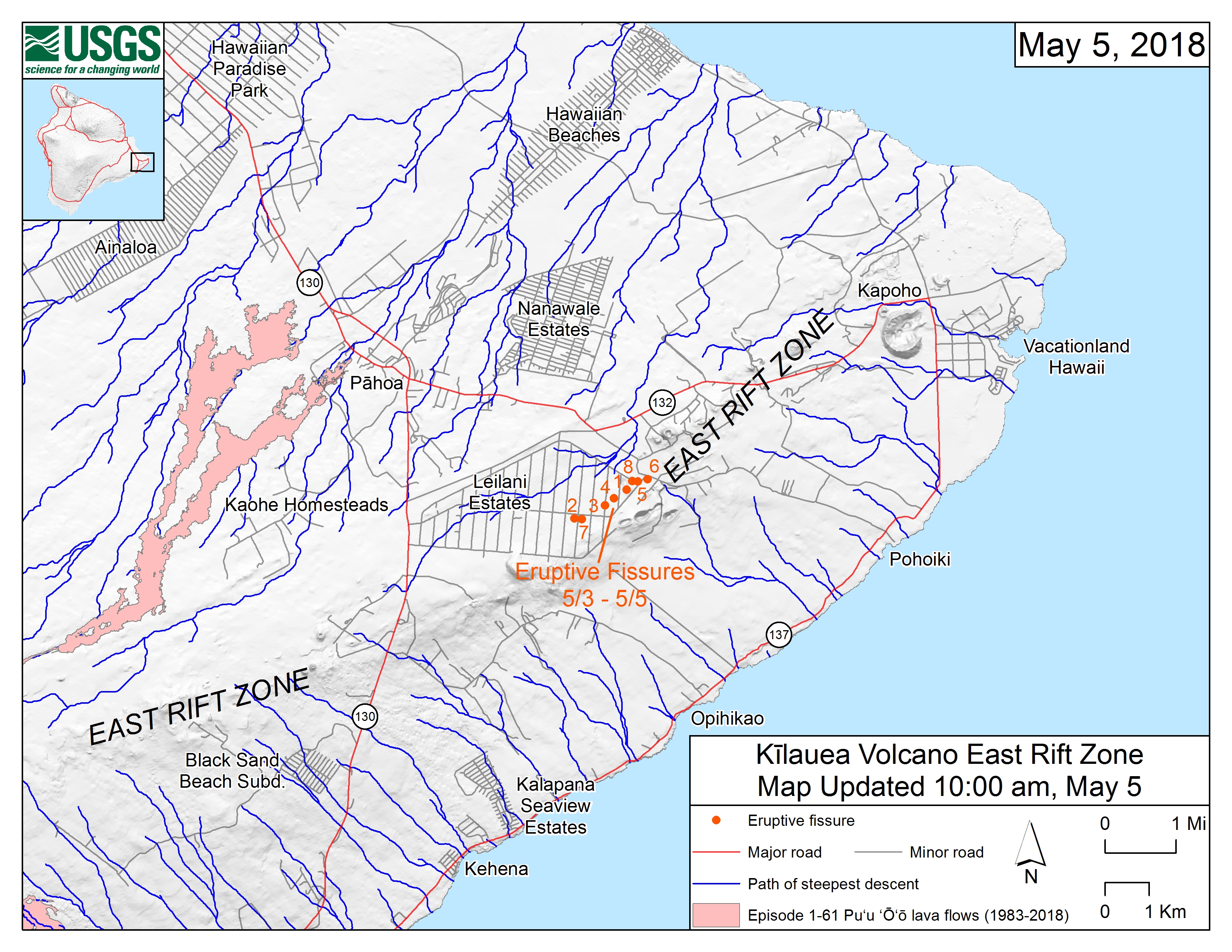
English: Map of the locations of eruptive fissures and the steepest descent paths in area of eruptive fissures, Kīlauea East Rift Zone; 10:00 a.m. HST (May 5, 2018) This map shows the locations of eruptive fissures in the order that they occurred in the Leilani Estates Subdivision as of 10:00 a.m. HST (May 5, 2018). The blue lines are paths of steepest descent that identify likely paths of a lava flow, if and when lava moves downhill from an erupting vent. The paths of steepest-descent were calculated from a 1983 digital elevation model (DEM) of the Island of Hawai‘i, created from digitized contours. Steepest-descent path analysis is based on the assumption that the DEM perfectly represents the earth's surface. DEMs, however, are not perfect, so the blue lines on this map can be used to infer only approximate lava-flow paths. The base shaded-relief map was made from the 1983 10-m (DEM). For additional explanation of steepest descent paths, see http://pubs.usgs.gov/of/2007/1264. For calculation details, ESRI shapefiles, and KMZ versions of steepest descent paths, see https://www.sciencebase.gov/catalog/item/57fd072ee4b0824b2d130eb5. |
| Date | |
| Source | https://volcanoes.usgs.gov/observatories/hvo/maps_uploads/image-409.jpg |
| Author | United States Geological Survey |
Licensing
This image is in the
public domain in the United States because it only contains materials that originally came from the
United States Geological Survey, an agency of the
United States Department of the Interior. For more information, see
the official USGS copyright policy.
|
File history
Click on a date/time to view the file as it appeared at that time.
| Date/Time | Thumbnail | Dimensions | User | Comment | |
|---|---|---|---|---|---|
| current | 16:44, 6 May 2018 |
| 3,300 × 2,550 (3.98 MB) | ThT | User created page with UploadWizard |
File usage
The following pages on the English Wikipedia use this file (pages on other projects are not listed):
Global file usage
The following other wikis use this file:
- Usage on ca.wikipedia.org
- Usage on de.wikipedia.org
- Usage on ja.wikipedia.org
- Usage on pt.wikipedia.org