This is a file from the Wikimedia Commons
From Wikipedia, the free encyclopedia

Original file(SVG file, nominally 189 × 360 pixels, file size: 3.66 MB)

Description
English: {| class="licensetpl" style="display:none"

|Public domainPublic domainfalsefalse |}

Public domain This work has been released into the public domain by its author, USGS, shapefile found here: http://gis.ucla.edu/geodata/dataset/north-america-telephone-area-code-boundaries. This applies worldwide.
In some countries this may not be legally possible; if so:
USGS, shapefile found here: http://gis.ucla.edu/geodata/dataset/north-america-telephone-area-code-boundaries grants anyone the right to use this work for any purpose, without any conditions, unless such conditions are required by law.


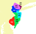
This is one of Psiĥedelisto's US telephone area code maps. They all have different color schemes because they are made to supersede a patchwork of existing maps on English Wikipedia. Around one per every two days were made between December 2, 2016 and (no end date yet! :) ).

Please let me know on my talk page if you have any problem with these standards.

Current maps and their projections:


Source
Public domain
This image is in the public domain in the United States because it only contains materials that originally came from the United States Geological Survey, an agency of the United States Department of the Interior. For more information, see the official USGS copyright policy.

Bahasa Indonesia  català  čeština  Deutsch  eesti  English  español  français  galego  italiano  Nederlands  português  polski  sicilianu  suomi  Tiếng Việt  Türkçe  български  македонски  русский  മലയാളം  한국어  日本語  中文  中文(简体)  中文(繁體)  العربية  فارسی  +/−

Author Psiĥedelisto
Other versions
SVG development
InfoField
 
The SVG code is valid.
 
This map was created with Inkscape.
 
and with QGIS.
 
 This map uses embedded text that can be easily translated using a text editor.

Information

Captions

Add a one-line explanation of what this file represents

Items portrayed in this file

depicts

File history

Click on a date/time to view the file as it appeared at that time.

Date/TimeThumbnailDimensionsUserComment
current 17:22, 31 July 2023 Thumbnail for version as of 17:22, 31 July 2023189 × 360 (3.66 MB)Kbrosecrop to smaller canvas
12:57, 25 June 2019 Thumbnail for version as of 12:57, 25 June 2019435 × 417 (3.67 MB)Kbrosecorrect number placement
13:37, 22 July 2017 Thumbnail for version as of 13:37, 22 July 2017435 × 417 (3.67 MB)PsiĥedelistoOverlayed new area code 640 over 609
06:38, 16 January 2017 Thumbnail for version as of 06:38, 16 January 2017408 × 391 (3.65 MB)Psiĥedelistofix wrong color of area code 609 barrier islands which was masked by outlines in previous version of image
21:45, 3 December 2016 Thumbnail for version as of 21:45, 3 December 2016408 × 391 (3.65 MB)KbroseRemove black emphasis of border lines
16:37, 2 December 2016 Thumbnail for version as of 16:37, 2 December 2016408 × 391 (3.67 MB)PsiĥedelistoI have gotten some feedback that my font choice was lacking - so this time I went for just `sans-serif` over Computer Modern. Apologies to Knuth ;)
14:42, 2 December 2016 Thumbnail for version as of 14:42, 2 December 2016408 × 391 (3.75 MB)Psiĥedelisto{{Information |Description ={{en|1={{PD-author|USGS, shapefile found here: http://gis.ucla.edu/geodata/dataset/north-america-telephone-area-code-boundaries}} {{Created with QGIS}} {{Created with Inkscape}} {{User:Psiĥedelisto/This_template_is_inclu...

Global file usage

The following other wikis use this file:

Metadata