
Original file (4,000 × 3,000 pixels, file size: 5.03 MB, MIME type: image/jpeg)
| This is a file from the
Wikimedia Commons. Information from its
description page there is shown below. Commons is a freely licensed media file repository. You can help. |
.jpg)
Summary
| Description |
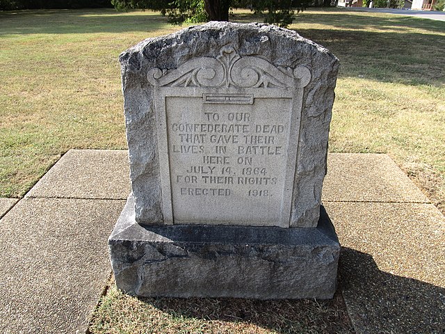
Tupelo National Battlefield, in Tupelo, Mississippi, commemorates the July 14–15, 1864, Battle of Tupelo in which Lieutenant General Nathan Bedford Forrest tried to cut the railroad supplying the Union's march on Atlanta. Established as Tupelo National Battlefield Site February 21, 1929; transferred from the War Department August 10, 1933; redesignated and boundary changed August 10, 1961. Listed on the National Register of Historic Places on October 15, 1966. Administered by the Natchez Trace Parkway. en.wikipedia.org/wiki/Tupelo_National_Battlefield en.wikipedia.org/wiki/Wikipedia:Text_of_Creative_Commons_... |
| Date | |
| Source |
Tupelo National Battlefield, Tupelo, Mississippi
|
| Author | Ken Lund from Las Vegas, Nevada, USA |
| Camera location |
| View this and other nearby images on: OpenStreetMap |
|
|---|
.jpg¶ms=034.255168_N_-088.736743_E_globe:Earth_type:camera_source:Flickr_&language=en)
Licensing
- You are free:
- to share – to copy, distribute and transmit the work
- to remix – to adapt the work
- Under the following conditions:
- attribution – You must give appropriate credit, provide a link to the license, and indicate if changes were made. You may do so in any reasonable manner, but not in any way that suggests the licensor endorses you or your use.
- share alike – If you remix, transform, or build upon the material, you must distribute your contributions under the same or compatible license as the original.
| This image, originally posted to Flickr, was reviewed on 24 November 2013 by the administrator or reviewer File Upload Bot (Magnus Manske), who confirmed that it was available on Flickr under the stated license on that date. |
File history
Click on a date/time to view the file as it appeared at that time.
| Date/Time | Thumbnail | Dimensions | User | Comment | |
|---|---|---|---|---|---|
| current | 11:23, 24 November 2013 |
| 4,000 × 3,000 (5.03 MB) | File Upload Bot (Magnus Manske) | Transferred from Flickr by User:clusternote |
File usage
Global file usage
The following other wikis use this file:
- Usage on fr.wikipedia.org
.jpg)