No higher resolution available.
Triple_Alliance.png (720 × 492 pixels, file size: 114 KB, MIME type: image/png)
| This is a file from the
Wikimedia Commons. Information from its
description page there is shown below. Commons is a freely licensed media file repository. You can help. |

|
This map image could be re-created using
vector graphics as an
SVG file. This has several advantages; see
Commons:Media for cleanup for more information. If an SVG form of this image is available, please upload it and afterwards replace this template with
{{
vector version available|new image name}}
.
It is recommended to name the SVG file “Triple Alliance.svg”—then the template Vector version available (or Vva) does not need the new image name parameter. |
Summary
| Description |
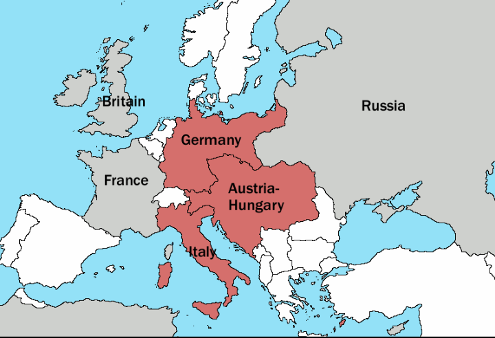
English: A simple map showing the Triple Alliance of Germany, Austria and Italy in 1913. The alliance members are puce, other great powers are grey. |
| Date | 27 February 2007 (original upload date) |
| Source | Transferred from en.wikipedia to Commons. |
| Author | Nydas at English Wikipedia |
Licensing
| This work has been released into the
public domain by its author,
Nydas at
English Wikipedia. This applies worldwide. In some countries this may not be legally possible; if so: Nydas grants anyone the right to use this work for any purpose, without any conditions, unless such conditions are required by law. |
Original upload log
The original description page was
here. All following user names refer to en.wikipedia.
- 2007-02-27 21:14 Nydas 796×542× (46654 bytes) A simple map, made by [[User:Nydas]], showing the Triple Alliance of Germany, Austria and Italy in 1913. Alliance members are puce, other great powers are grey.
- 2007-02-27 20:12 Nydas 796×542× (39447 bytes) A better triple alliance map, without the ugly pixel mess of the last one
File history
Click on a date/time to view the file as it appeared at that time.
| Date/Time | Thumbnail | Dimensions | User | Comment | |
|---|---|---|---|---|---|
| current | 14:39, 28 March 2019 |
| 720 × 492 (114 KB) | Barjimoa | Reverted to version as of 14:36, 28 March 2019 (UTC) |
| 14:38, 28 March 2019 |
 | 796 × 542 (46 KB) | Barjimoa | Reverted to version as of 14:32, 28 March 2019 (UTC) | |
| 14:36, 28 March 2019 |
 | 720 × 492 (114 KB) | Barjimoa | {{Information |Description= |Source= |Date= |Author= |Permission= |other_versions= }} | |
| 14:32, 28 March 2019 |
 | 796 × 542 (46 KB) | Barjimoa | Such a huge change should have had consensus. Only A-H, Germany and Italy were part of the Triple alliance. | |
| 09:59, 20 December 2018 |
 | 796 × 542 (42 KB) | Mentatus | Added Romania | |
| 21:13, 14 February 2011 |
 | 796 × 542 (46 KB) | OgreBot | (BOT): This is the version originally uploaded on 2007-02-27 21:14 (UTC) by Nydas; storing on commons for archival purposes | |
| 21:13, 14 February 2011 |
 | 796 × 542 (39 KB) | OgreBot | (BOT): This is the version originally uploaded on 2007-02-27 20:12 (UTC) by Nydas; storing on commons for archival purposes | |
| 16:29, 19 February 2008 |
 | 796 × 542 (46 KB) | Zubosud 89 | A simple map, made by en:User:Nydas, showing the Triple Alliance of Germany, Austria and Italy in 1913. The alliance members are puce, other great powers are grey. {{PD-user-w|en|english wikipedia|Nydas}}. |
File usage
The following pages on the English Wikipedia use this file (pages on other projects are not listed):
Global file usage
The following other wikis use this file:
- Usage on azb.wikipedia.org
- Usage on be.wikipedia.org
- Usage on bg.wikipedia.org
- Usage on bn.wikipedia.org
- Usage on cs.wikipedia.org
- Usage on da.wikipedia.org
- Usage on eo.wikipedia.org
- Usage on es.wikibooks.org
- Usage on et.wikipedia.org
- Usage on fa.wikipedia.org
- Usage on fi.wikipedia.org
- Usage on he.wikipedia.org
- Usage on hu.wikipedia.org
- Usage on id.wikipedia.org
- Usage on it.wikipedia.org
- Usage on ka.wikipedia.org
- Usage on kk.wikipedia.org
- Usage on mk.wikipedia.org
- Usage on ml.wikipedia.org
- Usage on ms.wikipedia.org
- Usage on mzn.wikipedia.org
- Usage on no.wikipedia.org
- Usage on pl.wikipedia.org
- Usage on pt.wikipedia.org
- Usage on pt.wikibooks.org
- Usage on ru.wikipedia.org
- Usage on sl.wikipedia.org
- Usage on so.wikipedia.org
- Usage on sv.wikipedia.org
- Usage on th.wikipedia.org
- Usage on tr.wikipedia.org
- Usage on uk.wikipedia.org
- Usage on uz.wikipedia.org
- Usage on vi.wikipedia.org
- Usage on zh.wikipedia.org
View more global usage of this file.