Size of this preview:
800 × 534 pixels. Other resolutions:
320 × 214 pixels |
640 × 427 pixels |
1,024 × 683 pixels |
1,280 × 854 pixels |
2,560 × 1,709 pixels |
7,360 × 4,912 pixels.
Original file (7,360 × 4,912 pixels, file size: 11.64 MB, MIME type: image/jpeg)
| This is a file from the
Wikimedia Commons. Information from its
description page there is shown below. Commons is a freely licensed media file repository. You can help. |
_-_Kaeng_Krachan_National_Park_(27493423545).jpg)
|
| This is a featured picture, which means that members of the community have identified it as one of the finest images on the English Wikipedia, adding significantly to its accompanying article. If you have a different image of similar quality, be sure to upload it using the proper free license tag, add it to a relevant article, and nominate it. |
|
| This image was selected as picture of the day on the English Wikipedia for October 30, 2022. |
Summary
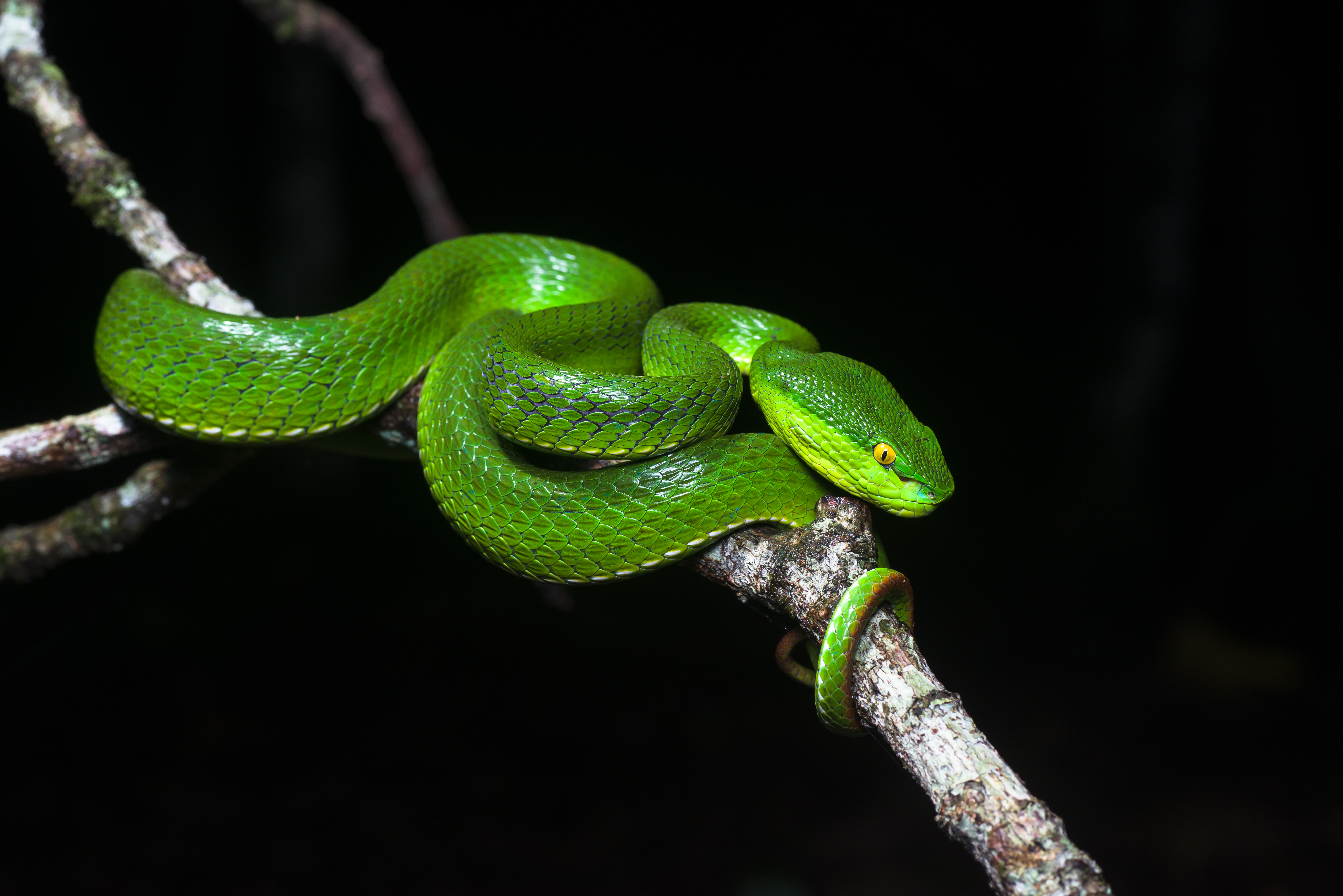
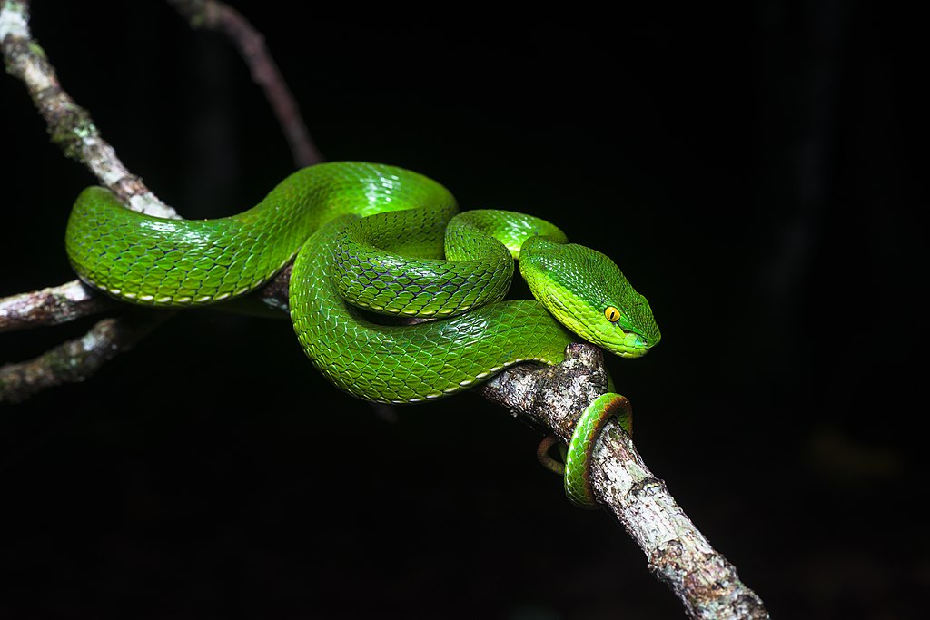
| Description | Female white-lipped pit viper (Trimeresurus albolabris) |
| Date | |
| Source | Trimeresurus albolabris, White-lipped pit viper (female) - Kaeng Krachan National Park |
| Author | Rushen |
| Camera location |
| View this and other nearby images on: OpenStreetMap |
|
|---|
_-_Kaeng_Krachan_National_Park_(27493423545).jpg¶ms=012.799194_N_0099.452962_E_globe:Earth_type:camera_source:Flickr_&language=en)
|
_-_Kaeng_Krachan_National_Park_(27493423545).jpg)
Licensing
This file is licensed under the
Creative Commons
Attribution-Share Alike 2.0 Generic license.
- You are free:
- to share – to copy, distribute and transmit the work
- to remix – to adapt the work
- Under the following conditions:
- attribution – You must give appropriate credit, provide a link to the license, and indicate if changes were made. You may do so in any reasonable manner, but not in any way that suggests the licensor endorses you or your use.
- share alike – If you remix, transform, or build upon the material, you must distribute your contributions under the same or compatible license as the original.
| This image was originally posted to Flickr by Rushen! at https://flickr.com/photos/87521289@N07/27493423545 ( archive). It was reviewed on 26 May 2019 by FlickreviewR 2 and was confirmed to be licensed under the terms of the cc-by-sa-2.0. |
Photographs by Rushen
File history
Click on a date/time to view the file as it appeared at that time.
| Date/Time | Thumbnail | Dimensions | User | Comment | |
|---|---|---|---|---|---|
| current | 18:37, 26 May 2019 |
| 7,360 × 4,912 (11.64 MB) | B2Belgium | Transferred from Flickr via #flickr2commons |
File usage
The following pages on the English Wikipedia use this file (pages on other projects are not listed):
- List of reptiles of Nepal
- List of reptiles of Sumatra
- Trimeresurus
- Trimeresurus albolabris
- Talk:Trimeresurus albolabris
- User talk:B2Belgium
- User talk:MER-C/archives/48
- User talk:MER-C/archives/60
- User talk:Rushenb
- Wikipedia:Featured picture candidates/February-2020
- Wikipedia:Featured picture candidates/Trimeresurus albolabris
- Wikipedia:Featured pictures/Animals/Reptiles
- Wikipedia:Featured pictures thumbs/66
- Wikipedia:Main Page history/2022 October 30
- Wikipedia:Main Page history/2022 October 30b
- Wikipedia:Picture of the day/October 2022
- Wikipedia:WikiProject Amphibians and Reptiles/Automated list of recognized content
- Wikipedia:WikiProject Amphibians and Reptiles/Recognized content
- Wikipedia:WikiProject Thailand
- Wikipedia:WikiProject Thailand/Recognized content
- Template:POTD/2022-10-30
Global file usage
The following other wikis use this file:
- Usage on as.wikipedia.org
- Usage on bg.wikipedia.org
- Usage on bn.wikipedia.org
- Usage on ceb.wikipedia.org
- Usage on cs.wikipedia.org
- Usage on da.wikipedia.org
- Usage on de.wikipedia.org
- Usage on en.wiktionary.org
- Usage on eu.wikipedia.org
- Usage on fa.wikipedia.org
- Usage on fr.wikipedia.org
- Usage on hu.wikipedia.org
- Usage on id.wikipedia.org
- Usage on jv.wikipedia.org
- Usage on ms.wikipedia.org
- Usage on my.wikipedia.org
- Usage on ne.wikipedia.org
- Usage on nv.wikipedia.org
- Usage on pnb.wikipedia.org
- Usage on pt.wikipedia.org
- Usage on ro.wikipedia.org
- Usage on sg.wiktionary.org
- Usage on species.wikimedia.org
- Usage on su.wikipedia.org
- Usage on sv.wikipedia.org
- Usage on th.wikipedia.org
- Usage on tr.wikipedia.org
- Usage on uk.wikipedia.org
- Usage on vi.wikipedia.org
- Usage on war.wikipedia.org
- Usage on www.wikidata.org
- Usage on zh.wikipedia.org
_-_Kaeng_Krachan_National_Park_(27493423545).jpg&oldid=1090838377)