No higher resolution available.
Tranquillitatis_basin_topo.jpg (500 × 500 pixels, file size: 39 KB, MIME type: image/jpeg)
| This is a file from the
Wikimedia Commons. Information from its
description page there is shown below. Commons is a freely licensed media file repository. You can help. |
Summary
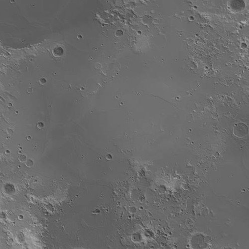
| Description |
English:
Mare Tranquillitatis topographic map (light gray=high, dark gray=low). Generated from LOLA 1024ppd Elevation - Numeric layer with
LRO-WAC Shaded Relief layer at 30% opacity overlain. |
| Date | |
| Source |
Transferred from en.wikipedia to Commons. (Original text: JMARS) |
| Author | James Stuby / NASA / Arizona State Univ. |
Licensing
| This file is in the public domain in the United States because it was solely created by NASA. NASA copyright policy states that "NASA material is not protected by copyright unless noted". (See Template:PD-USGov, NASA copyright policy page or JPL Image Use Policy.) | ||
 |
Warnings:
|
Original upload log
The original description page was
here. All following user names refer to en.wikipedia.
| Date/Time | Dimensions | User | Comment |
|---|---|---|---|
| 2016-01-25 02:36 | 500×500× (39669 bytes) | Jstuby | {{Information |Description =[[Mare Tranquillitatis]] topographic map (light gray=high, dark gray=low). Generated from ''LOLA 1024ppd Elevation - Numeric'' layer with ''[[Lunar Reconnaissance Orbiter|LRO]]-WAC Shaded Relief'' layer at 30% opacity ov... |
File history
Click on a date/time to view the file as it appeared at that time.
| Date/Time | Thumbnail | Dimensions | User | Comment | |
|---|---|---|---|---|---|
| current | 02:47, 16 March 2016 |
| 500 × 500 (39 KB) | FastilyClone | Transferred from enwp |
File usage
The following pages on the English Wikipedia use this file (pages on other projects are not listed):
Global file usage
The following other wikis use this file:
- Usage on hy.wikipedia.org
- Usage on lt.wikipedia.org
- Usage on pt.wikipedia.org
- Usage on ro.wikipedia.org
- Usage on zh.wikipedia.org