
Size of this preview:
800 × 508 pixels. Other resolutions:
320 × 203 pixels |
640 × 407 pixels |
1,024 × 651 pixels |
1,280 × 814 pixels |
1,800 × 1,144 pixels.
Original file (1,800 × 1,144 pixels, file size: 556 KB, MIME type: image/jpeg)
| This is a file from the
Wikimedia Commons. Information from its
description page there is shown below. Commons is a freely licensed media file repository. You can help. |
Summary
| Description |
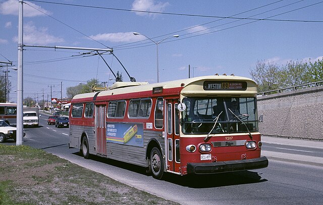
English: Toronto Transit Commission
trolleybus 9287 on route 89-Weston Road in 1987, in
Toronto, Ontario. It is travelling south on Weston Road just north of Albion Road/Walsh Avenue, starting a new trip on route 89. The vehicle was built in 1972 by Flyer Industries Ltd. (which later became
New Flyer Industries), but fitted – by the TTC's own staff – with recycled electrical equipment taken from 1947/48
CCF-
Brill trolleybuses being retired. Route 89 reached this location when a very short extension of the 1948-opened route came into use, in April 1973. Toronto's Flyer trolleybuses were withdrawn in January 1992, and service on route 89 also ended permanently in that month. The last trolleybus service in Toronto (routes 4 and 6) ended in July 1993. |
| Date | Taken on 1 May 1987 |
| Source | Own work |
| Author | Steve Morgan |
| Permission ( Reusing this file) |
See below; user MUST attribute the photographer (Steve Morgan) on any reuse outside Wikipedia. |
| Camera location |
| View this and other nearby images on: OpenStreetMap |
|
|---|
Licensing
I, the copyright holder of this work, hereby publish it under the following licenses:
This file is licensed under the
Creative Commons
Attribution-Share Alike 3.0 Unported license.
- You are free:
- to share – to copy, distribute and transmit the work
- to remix – to adapt the work
- Under the following conditions:
- attribution – You must give appropriate credit, provide a link to the license, and indicate if changes were made. You may do so in any reasonable manner, but not in any way that suggests the licensor endorses you or your use.
- share alike – If you remix, transform, or build upon the material, you must distribute your contributions under the same or compatible license as the original.

|
Permission is granted to copy, distribute and/or modify this document under the terms of the GNU Free Documentation License, Version 1.2 or any later version published by the Free Software Foundation; with no Invariant Sections, no Front-Cover Texts, and no Back-Cover Texts. A copy of the license is included in the section entitled GNU Free Documentation License. |
You may select the license of your choice.
File history
Click on a date/time to view the file as it appeared at that time.
| Date/Time | Thumbnail | Dimensions | User | Comment | |
|---|---|---|---|---|---|
| current | 11:57, 28 June 2015 |
| 1,800 × 1,144 (556 KB) | Steve Morgan | small adjustments to levels, color |
| 11:12, 27 September 2010 |
 | 1,800 × 1,144 (537 KB) | Steve Morgan | {{Information |Description={{en|1=Toronto Transit Commission trolleybus 9287 on route 89-Weston Road in 1987, in Toronto, Ontario. It is travelling south on Weston Road just north of Albion Road/Walsh Avenue. The vehicle w |
File usage
The following pages on the English Wikipedia use this file (pages on other projects are not listed):
Global file usage
The following other wikis use this file:
- Usage on bn.wikipedia.org
- Usage on es.wikipedia.org
- Usage on he.wikipedia.org
- Usage on io.wikipedia.org
- Usage on ko.wikipedia.org