
Size of this preview:
346 × 600 pixels. Other resolutions:
138 × 240 pixels |
277 × 480 pixels |
443 × 768 pixels |
591 × 1,024 pixels |
1,181 × 2,048 pixels |
3,000 × 5,200 pixels.
Original file (3,000 × 5,200 pixels, file size: 3.27 MB, MIME type: image/jpeg)
| This is a file from the
Wikimedia Commons. Information from its
description page there is shown below. Commons is a freely licensed media file repository. You can help. |
Summary
| Description |
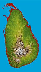
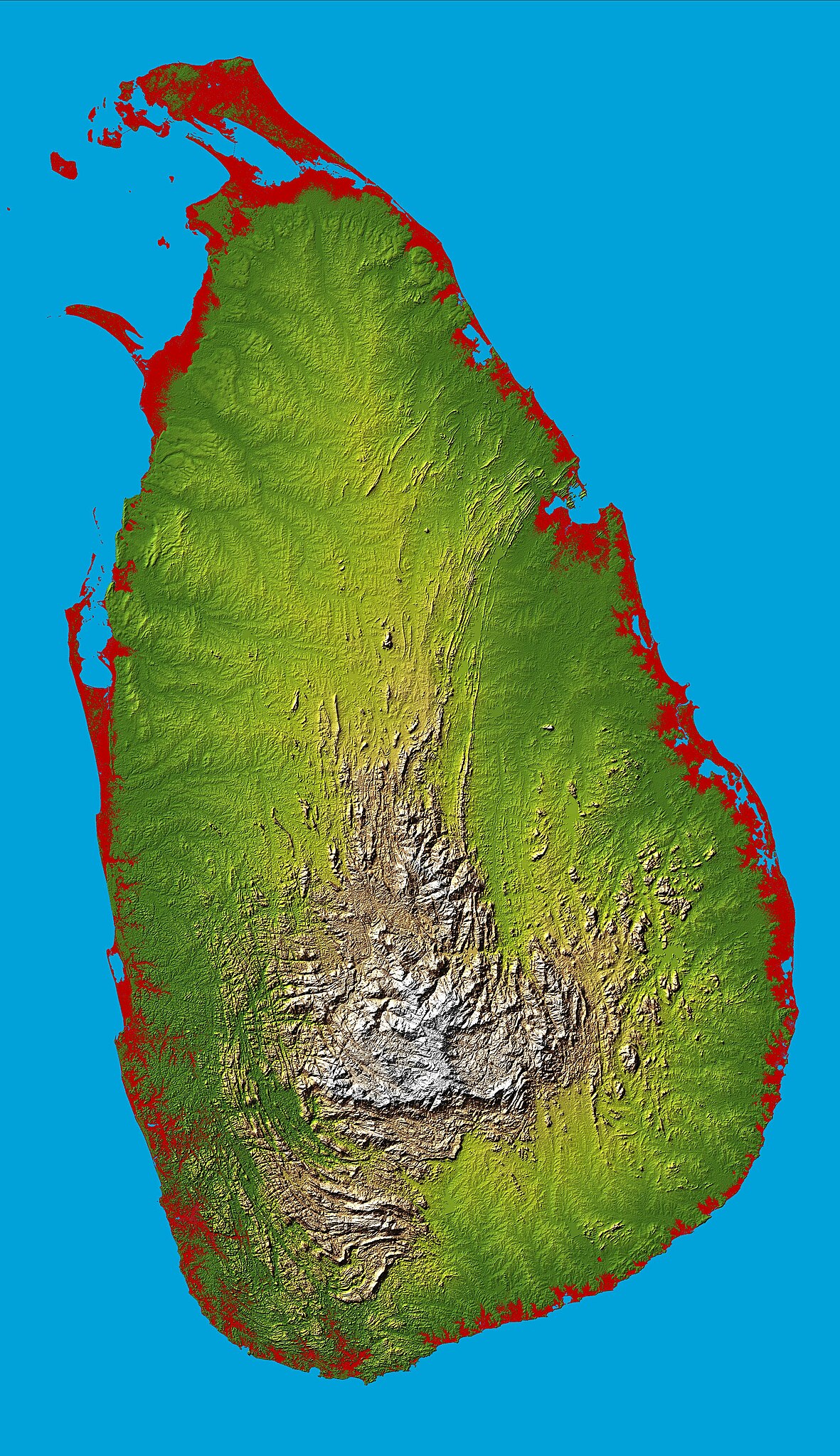
English: Topography of
Sri Lanka, obtained from the
Shuttle Radar Topography Mission of
STS-99, aboard the
Space Shuttle Endeavour. Heights below 10 meters (33 feet) above sea level have been colored red. |
| Date | |
| Source | http://photojournal.jpl.nasa.gov/catalog/PIA06670 |
| Author | National Aeronautics & Space Administration |
| Object location |
| View this and other nearby images on: OpenStreetMap |
|
|---|
Licensing
| This file is in the public domain in the United States because it was solely created by NASA. NASA copyright policy states that "NASA material is not protected by copyright unless noted". (See Template:PD-USGov, NASA copyright policy page or JPL Image Use Policy.) | ||
 |
Warnings:
|
File history
Click on a date/time to view the file as it appeared at that time.
| Date/Time | Thumbnail | Dimensions | User | Comment | |
|---|---|---|---|---|---|
| current | 17:43, 27 March 2005 |
| 3,000 × 5,200 (3.27 MB) | FEXX | {{PD-USGov-NASA}} |
File usage
The following pages on the English Wikipedia use this file (pages on other projects are not listed):
- Geography of Sri Lanka
- Outline of Sri Lanka
- Sri Lanka
- User:Blackknight12/sandbox
- User:DaisyGeekyTransGirl
- User:Deavenger
- User:Djodjo666
- User:JFoog
- User:Okiloma
- User:ProudIrishAspie
- User:RitigalaJayasena/UserBoxes/EquitySriLanka
- User:Trengarasu
- Wikipedia:Graphics Lab/Map workshop/Archive/Dec 2015
- Wikipedia:Userboxes/Politics by country/Sri Lanka
- Portal:Sri Lanka
Global file usage
The following other wikis use this file:
- Usage on af.wikipedia.org
- Usage on ar.wikipedia.org
- Usage on arz.wikipedia.org
- Usage on ast.wikipedia.org
- Usage on az.wikipedia.org
- Usage on bcl.wikipedia.org
- Usage on be.wikipedia.org
- Usage on bg.wikipedia.org
- Usage on bg.wiktionary.org
- Usage on bn.wikipedia.org
- Usage on ca.wikipedia.org
- Usage on ceb.wikipedia.org
- Usage on de.wikipedia.org
- Usage on de.wikivoyage.org
- Usage on diq.wikipedia.org
- Usage on el.wikipedia.org
- Usage on en.wikiversity.org
- Usage on eo.wikipedia.org
- Usage on es.wikipedia.org
- Usage on et.wikipedia.org
- Usage on fa.wikipedia.org
- Usage on fi.wikipedia.org
- Usage on fr.wikipedia.org
- Usage on fr.wikinews.org
- Usage on fr.wikivoyage.org
- Usage on ga.wikipedia.org
- Usage on gl.wikipedia.org
- Usage on gu.wikipedia.org
- Usage on ha.wikipedia.org
- Usage on he.wiktionary.org
- Usage on hi.wikipedia.org
- Usage on hr.wikipedia.org
- Usage on ht.wikipedia.org
- Usage on hy.wikipedia.org
View more global usage of this file.