
Size of this preview:
800 × 496 pixels. Other resolutions:
320 × 198 pixels |
640 × 397 pixels |
1,024 × 635 pixels |
1,280 × 794 pixels |
2,195 × 1,361 pixels.
Original file (2,195 × 1,361 pixels, file size: 1,005 KB, MIME type: image/jpeg)
| This is a file from the
Wikimedia Commons. Information from its
description page there is shown below. Commons is a freely licensed media file repository. You can help. |
Summary
| Description |
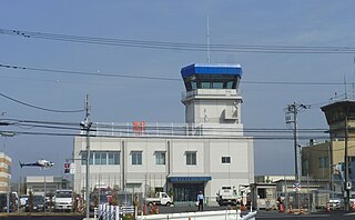
English: Tokyo Heliport (東京へリポート Tōkyō Heripōto) is a heliport in Kōtō, Tokyo, Japan, mainly used for chartered flights in the Greater Tokyo Area. This image was stitched together from two images in order to give a larger field of view. The helicopter was actually in the original shot (lucky shot!) but it has been touched up in the stitched image so that it shows up clearly. This new image clearly shows the buildings have changed since the last image uploaded to Commons. |
| Date | |
| Source | Own work |
| Author | Nesnad |
| Camera location |
| View this and other nearby images on: OpenStreetMap |
|
|---|
Licensing
I, the copyright holder of this work, hereby publish it under the following licenses:
This file is licensed under the
Creative Commons
Attribution-Share Alike 3.0 Unported license.
- You are free:
- to share – to copy, distribute and transmit the work
- to remix – to adapt the work
- Under the following conditions:
- attribution – You must give appropriate credit, provide a link to the license, and indicate if changes were made. You may do so in any reasonable manner, but not in any way that suggests the licensor endorses you or your use.
- share alike – If you remix, transform, or build upon the material, you must distribute your contributions under the same or compatible license as the original.

|
Permission is granted to copy, distribute and/or modify this document under the terms of the GNU Free Documentation License, Version 1.2 or any later version published by the Free Software Foundation; with no Invariant Sections, no Front-Cover Texts, and no Back-Cover Texts. A copy of the license is included in the section entitled GNU Free Documentation License. |
You may select the license of your choice.
File history
Click on a date/time to view the file as it appeared at that time.
| Date/Time | Thumbnail | Dimensions | User | Comment | |
|---|---|---|---|---|---|
| current | 16:52, 11 April 2011 |
| 2,195 × 1,361 (1,005 KB) | Nesnad | {{Information |Description ={{en|1=Tokyo Heliport (東京へリポート Tōkyō Heripōto) is a heliport in Kōtō, Tokyo, Japan, mainly used for chartered flights in the Greater Tokyo Area. This image was stitched together from two images in order to |
File usage
The following pages on the English Wikipedia use this file (pages on other projects are not listed):
Global file usage
The following other wikis use this file:
- Usage on de.wikipedia.org
- Usage on fa.wikipedia.org
- Usage on ko.wikipedia.org
- Usage on ru.wikipedia.org
- Usage on tg.wikipedia.org