
Size of this preview:
634 × 599 pixels. Other resolutions:
254 × 240 pixels |
508 × 480 pixels |
812 × 768 pixels |
1,083 × 1,024 pixels |
2,211 × 2,090 pixels.
Original file (2,211 × 2,090 pixels, file size: 593 KB, MIME type: image/png)
| This is a file from the
Wikimedia Commons. Information from its
description page there is shown below. Commons is a freely licensed media file repository. You can help. |
Summary
| Description |
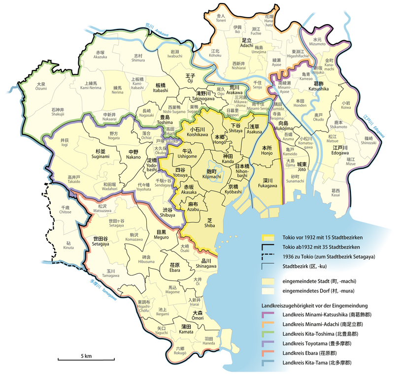
Deutsch: Karte der Bildung von
Groß-Tokio durch Eingemeindungen in den Jahren 1932 und 1936
English: Map of
Tokyo's mergers 1932–1936 |
|
| Date | ||
| Source |
Own work, using
|
|
| Author | NordNordWest | |
| Permission ( Reusing this file) |
This file is licensed under the
Creative Commons
Attribution-Share Alike 3.0 Germany license.
 |


|
This map has been made or improved in the German
Kartenwerkstatt (Map Lab). You can
propose maps to improve as well.
|
Licensing
This file is licensed under the
Creative Commons
Attribution-Share Alike 3.0 Germany license.
- You are free:
- to share – to copy, distribute and transmit the work
- to remix – to adapt the work
- Under the following conditions:
- attribution – You must give appropriate credit, provide a link to the license, and indicate if changes were made. You may do so in any reasonable manner, but not in any way that suggests the licensor endorses you or your use.
- share alike – If you remix, transform, or build upon the material, you must distribute your contributions under the same or compatible license as the original.
File history
Click on a date/time to view the file as it appeared at that time.
| Date/Time | Thumbnail | Dimensions | User | Comment | |
|---|---|---|---|---|---|
| current | 18:11, 4 October 2012 |
| 2,211 × 2,090 (593 KB) | NordNordWest | == {{int:filedesc}} == {{Information |Description= {{de|Karte der Bildung von Groß-Tokio durch Eingemeindungen in den Jahren 1932 und 1936}} {{en|Map of Tokyo's mergers 1932–1936}} |Source={{Own}}, using * ht... |
File usage
The following pages on the English Wikipedia use this file (pages on other projects are not listed):
Global file usage
The following other wikis use this file:
- Usage on ca.wikipedia.org
- Usage on da.wikipedia.org
- Usage on de.wikipedia.org
- Usage on fi.wikipedia.org
- Usage on fr.wikipedia.org
- Usage on id.wikipedia.org
- Usage on it.wikipedia.org
- Usage on ja.wikipedia.org
- Usage on ko.wikipedia.org
- Usage on ms.wikipedia.org
- Usage on th.wikipedia.org
- Usage on vi.wikipedia.org
- Usage on www.wikidata.org
- Usage on zh.wikipedia.org