No higher resolution available.
Tidal_Bore_-_geograph.org.uk_-_324581.jpg (640 × 461 pixels, file size: 77 KB, MIME type: image/jpeg)
| This is a file from the
Wikimedia Commons. Information from its
description page there is shown below. Commons is a freely licensed media file repository. You can help. |
Summary
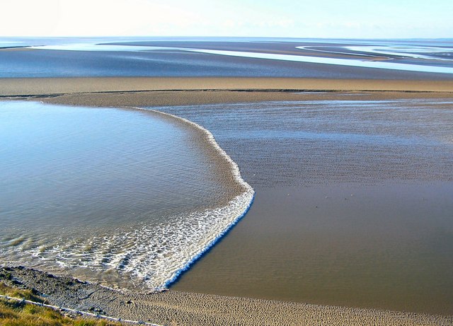
| Description |
English: Tidal Bore The channels are constantly changing and consequently not shown on the OS map. Here the tidal bore is coming up a channel, one of several such channels in the estuary, on its way to Arnside some 8km away as the tide flows. It took 2 hours and 5 minutes to reach the viaduct at Arnside (shown in
324585) from this point. |
| Date | |
| Source | From geograph.org.uk |
| Author | Arnold Price |
| Attribution ( required by the license) | Arnold Price / Tidal Bore / |
| Object location | | View this and other nearby images on: OpenStreetMap |
|
|---|
_heading:202.00&language=en)
Licensing

|
This image was taken from the
Geograph project collection. See
this photograph's page on the Geograph website for the photographer's contact details. The copyright on this image is owned by Arnold Price and is licensed for reuse under the
Creative Commons Attribution-ShareAlike 2.0 license.
|
This file is licensed under the
Creative Commons
Attribution-Share Alike 2.0 Generic license.
Attribution: Arnold Price
- You are free:
- to share – to copy, distribute and transmit the work
- to remix – to adapt the work
- Under the following conditions:
- attribution – You must give appropriate credit, provide a link to the license, and indicate if changes were made. You may do so in any reasonable manner, but not in any way that suggests the licensor endorses you or your use.
- share alike – If you remix, transform, or build upon the material, you must distribute your contributions under the same or compatible license as the original.
File history
Click on a date/time to view the file as it appeared at that time.
| Date/Time | Thumbnail | Dimensions | User | Comment | |
|---|---|---|---|---|---|
| current | 19:45, 30 December 2010 |
| 640 × 461 (77 KB) | GeographBot | == {{int:filedesc}} == {{Information |description={{en|1=Tidal Bore The channels are constantly changing and consequently not shown on the OS map. Here the tidal bore is coming up a channel, one of several such channels in the estuary, on its way to Arnsi |
File usage
The following pages on the English Wikipedia use this file (pages on other projects are not listed):
Global file usage
The following other wikis use this file:
- Usage on ar.wikipedia.org
- Usage on bn.wikipedia.org
- Usage on es.wikipedia.org
- Usage on fa.wikipedia.org
- Usage on fr.wikipedia.org
- Usage on fr.wikiversity.org
- Usage on ga.wikipedia.org
- Usage on he.wikipedia.org
- Usage on ms.wikipedia.org
- Usage on oc.wikipedia.org
- Usage on ro.wikipedia.org
- Usage on sl.wikipedia.org
- Usage on tr.wikipedia.org
- Usage on uk.wikipedia.org
- Usage on zh-yue.wikipedia.org