Size of this preview:
800 × 533 pixels. Other resolutions:
320 × 213 pixels |
640 × 427 pixels |
1,024 × 683 pixels |
1,280 × 853 pixels |
2,560 × 1,707 pixels |
3,504 × 2,336 pixels.
Original file (3,504 × 2,336 pixels, file size: 6.71 MB, MIME type: image/jpeg)
| This is a file from the
Wikimedia Commons. Information from its
description page there is shown below. Commons is a freely licensed media file repository. You can help. |
Summary
| Description |
English:
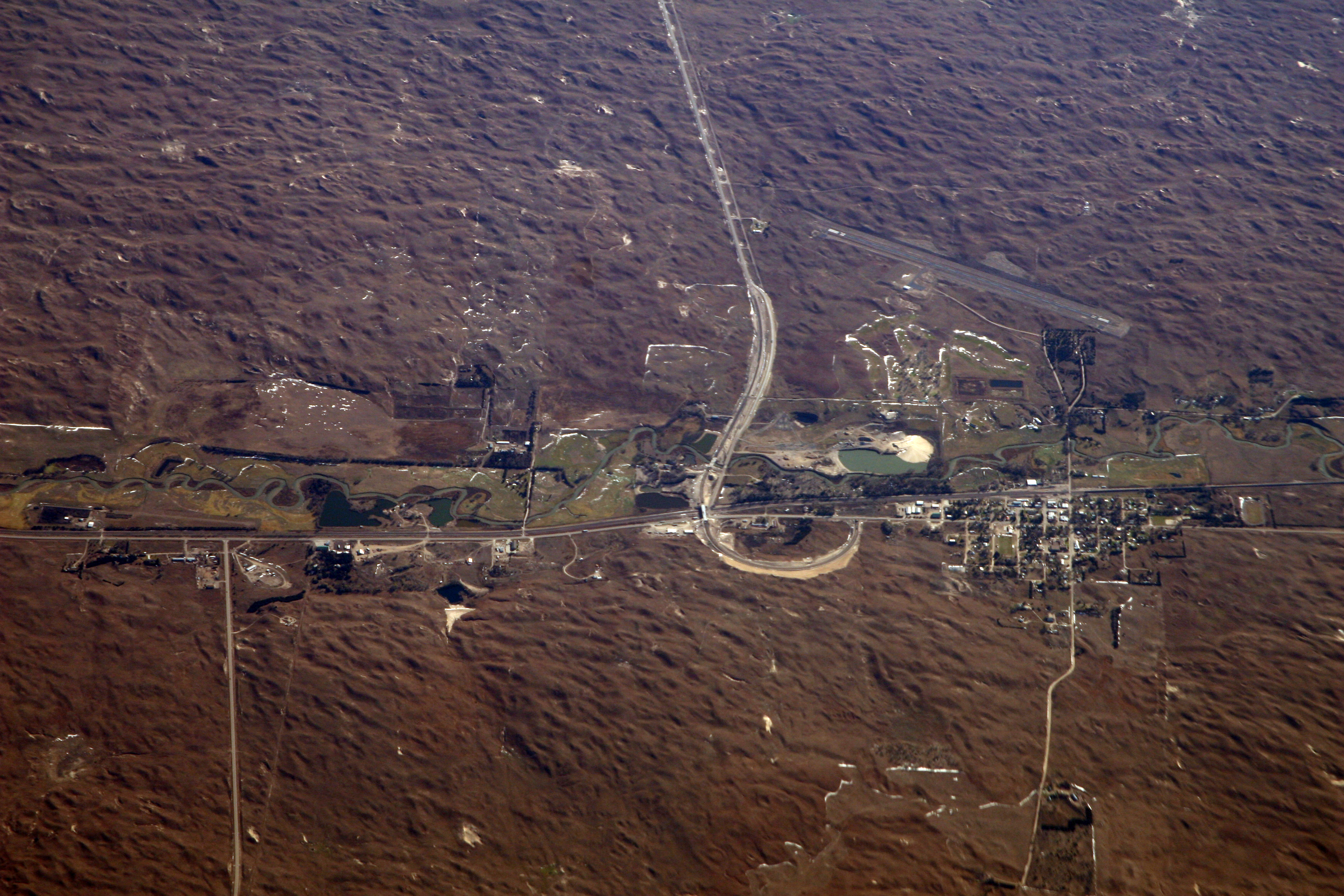
Thedford, Nebraska, in the midst of Nebraska's vast sand hills country. Nearest town to the
Nebraska National Forest (far upper left corner), an anomalous patch of dark evergreen furrows on the
sandhills of Nebraska. Says Wikipedia, "It was established in 1902 by
Charles E. Bessey as an experiment to see if forests could be created in treeless areas of the Great Plains for use as a national timber reserve. This effort resulted in a 20,000-acre (80.9 km²) forest, the largest human-planted forest in the United States." From the air it is the most remarkable feature in the region. |
| Date | |
| Source |
|
| Author | Doc Searls from Santa Barbara, USA |
| Object location |
| View this and other nearby images on: OpenStreetMap |
|
|---|
|
|
Open this image as an overlay in Google Earth ( Google Maps, Bing) | ( Help| Source) |
Licensing
This file is licensed under the
Creative Commons
Attribution-Share Alike 2.0 Generic license.
- You are free:
- to share – to copy, distribute and transmit the work
- to remix – to adapt the work
- Under the following conditions:
- attribution – You must give appropriate credit, provide a link to the license, and indicate if changes were made. You may do so in any reasonable manner, but not in any way that suggests the licensor endorses you or your use.
- share alike – If you remix, transform, or build upon the material, you must distribute your contributions under the same or compatible license as the original.
| This image, originally posted to Flickr, was reviewed on January 22, 2010 by the administrator or reviewer File Upload Bot (Magnus Manske), who confirmed that it was available on Flickr under the stated license on that date. |
| Annotations | This image is annotated: View the annotations at Commons |
File history
Click on a date/time to view the file as it appeared at that time.
| Date/Time | Thumbnail | Dimensions | User | Comment | |
|---|---|---|---|---|---|
| current | 21:31, 22 January 2010 |
| 3,504 × 2,336 (6.71 MB) | File Upload Bot (Magnus Manske) | {{Information |Description=Thedford, Nebraska, in the midst of Nebraska's vast sand hills country. Nearest town to the [http://en.wikipedia.org/wiki/Nebraska_National_Forest Nebraska National Forest], an anomalous patch of dark evergreen furrows on the [h |
File usage
The following pages on the English Wikipedia use this file (pages on other projects are not listed):
Global file usage
The following other wikis use this file:
- Usage on ar.wikipedia.org
- Usage on azb.wikipedia.org
- Usage on ca.wikipedia.org
- Usage on ceb.wikipedia.org
- Usage on es.wikipedia.org
- Usage on eu.wikipedia.org
- Usage on fa.wikipedia.org
- Usage on fr.wikipedia.org
- Usage on ht.wikipedia.org
- Usage on hu.wikipedia.org
- Usage on it.wikipedia.org
- Usage on ky.wikipedia.org
- Usage on lld.wikipedia.org
- Usage on pl.wikipedia.org
- Usage on pt.wikipedia.org
- Usage on sr.wikipedia.org
- Usage on sv.wikipedia.org
- Usage on uk.wikipedia.org
- Usage on www.wikidata.org
- Usage on zh-min-nan.wikipedia.org
- Usage on zh.wikipedia.org