
Size of this PNG preview of this SVG file:
459 × 600 pixels. Other resolutions:
184 × 240 pixels |
367 × 480 pixels |
588 × 768 pixels |
783 × 1,024 pixels |
1,567 × 2,048 pixels |
919 × 1,201 pixels.
Original file (SVG file, nominally 919 × 1,201 pixels, file size: 1.1 MB)
| This is a file from the
Wikimedia Commons. Information from its
description page there is shown below. Commons is a freely licensed media file repository. You can help. |
Summary
| Description |
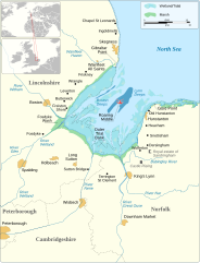
English: Map of The Wash, England.
|
||||||||||||||||||||||||||||||||||||||||||||||||||||||
| Date | |||||||||||||||||||||||||||||||||||||||||||||||||||||||
| Source |
Own work based on:
|
||||||||||||||||||||||||||||||||||||||||||||||||||||||
| Author | Goran_tek-en | ||||||||||||||||||||||||||||||||||||||||||||||||||||||
| Permission ( Reusing this file) |
This file is licensed under the
Creative Commons
Attribution-Share Alike 4.0 International license. Attribution: Goran_tek-en
|
||||||||||||||||||||||||||||||||||||||||||||||||||||||
| Other versions |
|
||||||||||||||||||||||||||||||||||||||||||||||||||||||
| SVG development | This
vector image was created with
Inkscape. |
||||||||||||||||||||||||||||||||||||||||||||||||||||||


| Object location |
| View this and other nearby images on: OpenStreetMap |
|
|---|

File history
Click on a date/time to view the file as it appeared at that time.
| Date/Time | Thumbnail | Dimensions | User | Comment | |
|---|---|---|---|---|---|
| current | 17:06, 16 April 2024 |
| 919 × 1,201 (1.1 MB) | Goran tek-en | added stuff requested by MOTORAL1987 |
| 17:59, 15 April 2024 |
 | 919 × 1,201 (1.09 MB) | Goran tek-en | stuff added as requested by MOTORAL1987 | |
| 15:43, 7 April 2024 |
 | 919 × 1,201 (1.09 MB) | Goran tek-en | added villages, removed color as agreed MOTORAL1987 | |
| 16:35, 1 April 2024 |
 | 919 × 1,201 (1.15 MB) | Goran tek-en | added stuff requested by MOTORAL1987 | |
| 12:37, 1 April 2024 |
 | 919 × 1,201 (1.12 MB) | Goran tek-en | changed counties color rerquested by MOTORAL1987 | |
| 16:11, 12 March 2024 |
 | 919 × 1,201 (1.12 MB) | Goran tek-en | added more as requested by MOTORAL1987 | |
| 14:56, 12 March 2024 |
 | 919 × 1,201 (1.12 MB) | Goran tek-en | more info added as requested by MOTORAL1987 | |
| 13:00, 6 March 2024 |
 | 919 × 1,201 (1.12 MB) | Goran tek-en | added points of interset requested by MOTORAL1987 | |
| 16:24, 5 March 2024 |
 | 919 × 1,201 (1.1 MB) | Goran tek-en | added scale | |
| 15:52, 3 March 2024 |
 | 919 × 1,201 (1.1 MB) | Goran tek-en | Long Sutton city requested by MOTORAL1987 |
File usage
The following pages on the English Wikipedia use this file (pages on other projects are not listed):
Global file usage
The following other wikis use this file:
- Usage on de.wikipedia.org
- Usage on es.wikipedia.org
- Usage on fr.wikipedia.org
- Usage on it.wikipedia.org
- Usage on nl.wikipedia.org
- Usage on pl.wikipedia.org
- Usage on pt.wikipedia.org
- Usage on simple.wikipedia.org