
Size of this preview:
436 × 600 pixels. Other resolutions:
174 × 240 pixels |
349 × 480 pixels |
558 × 768 pixels |
744 × 1,024 pixels |
1,488 × 2,048 pixels |
6,781 × 9,330 pixels.
Original file (6,781 × 9,330 pixels, file size: 10.53 MB, MIME type: image/jpeg)
| This is a file from the
Wikimedia Commons. Information from its
description page there is shown below. Commons is a freely licensed media file repository. You can help. |
Summary
| Description |
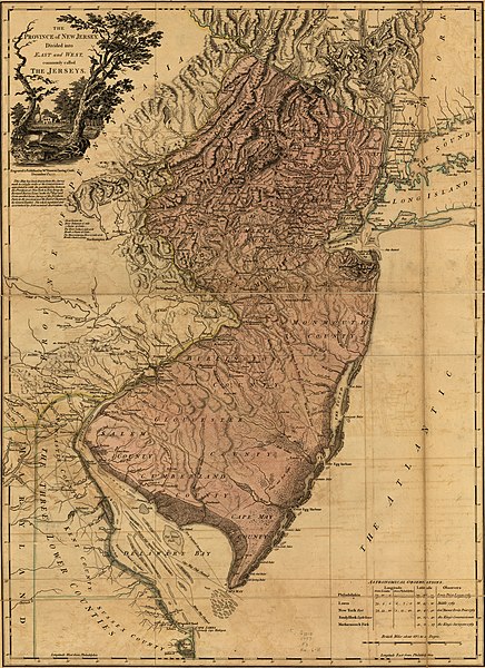
English: Scale ca. 1:420,000. Hand colored. LC copy 2 imperfect: Deteriorated in margins. Prime meridian: Philadelphia. Relief shown by hachures. Shows county boundaries and "Division line run in 1743 between East New Jersey and West New Jersey." "This map has been drawn from the survey made in 1769 ... by Bernard Ratzer ... and from another large survey of the northern parts ... by Gerard Banker." Appears in William Faden's The North American atlas. 1777. Includes table of "Astronomical observations." LC Maps of North America, 1750-1789, 1238 Available also through the Library of Congress Web site as a raster image. Includes table of "Astronomical observations." Vault AACR2: 100; 651/1; 651/2; 700/2 |
||
| Title | The Province of New Jersey, divided into East and West, commonly called the Jerseys. | ||
| Shelf ID | G3810 1777 .F3 | ||
| Date | |||
| Source | https://www.loc.gov/item/74692203/ | ||
| Author | Faden, William; Ratzer, Bernard; Bancker, Gerard | ||
| Permission ( Reusing this file) |
|
||
| Other versions | |||
| Location | New Jersey · United States | ||
| Part of | Military Battles And Campaigns · American Memory · Catalog · Geography And Map Division · American Revolution And Its Era: Maps And Charts Of North America And The West Indies, 1750-1789 | ||
| Subject | New Jersey · Maps · Early Works To 1800 · United States · Administrative And Political Divisions |


.jpg)
Licensing
|
This is a faithful photographic reproduction of a two-dimensional,
public domain work of art. The work of art itself is in the public domain for the following reason:
The official position taken by the Wikimedia Foundation is that "faithful reproductions of two-dimensional public domain works of art are public domain".
This photographic reproduction is therefore also considered to be in the public domain in the United States. In other jurisdictions, re-use of this content may be restricted; see Reuse of PD-Art photographs for details. | ||||
File history
Click on a date/time to view the file as it appeared at that time.
| Date/Time | Thumbnail | Dimensions | User | Comment | |
|---|---|---|---|---|---|
| current | 19:20, 19 March 2020 |
| 6,781 × 9,330 (10.53 MB) | Zeete | File:The Province of New Jersey, divided into East and West, commonly called the Jerseys. LOC 74692203.jpg cropped 3 % horizontally, 4 % vertically using CropTool with precise mode. |
File usage
The following pages on the English Wikipedia use this file (pages on other projects are not listed):
Global file usage
The following other wikis use this file:
- Usage on uz.wikipedia.org
- Usage on www.wikidata.org
.jpg)