Size of this preview:
536 × 600 pixels. Other resolutions:
214 × 240 pixels |
429 × 480 pixels |
686 × 768 pixels |
915 × 1,024 pixels |
1,831 × 2,048 pixels |
17,877 × 20,000 pixels.
Original file (17,877 × 20,000 pixels, file size: 4.2 MB, MIME type: image/png)
File history
Click on a date/time to view the file as it appeared at that time.
| Date/Time | Thumbnail | Dimensions | User | Comment | |
|---|---|---|---|---|---|
| current | 04:25, 5 April 2024 |
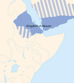
 | 17,877 × 20,000 (4.2 MB) | MotorolaBoy | Read the Ezana Stone again, and he campaigned in Wolkait, west of the Tekeze so added that territory. Also cleaned up parts of the image. If anyone else wants, they can improve the border by making it look nicer |
| 19:42, 1 April 2024 |
 | 17,877 × 20,000 (3.82 MB) | Obscure2020 | I didn't like how jagged and ugly the edges of the text looked, so here's a new version. I painted out the old text manually and replaced it. | |
| 17:40, 1 April 2024 |
 | 17,877 × 20,000 (3.82 MB) | Obscure2020 | From a distance, this image looks like it should be completely opaque. But it wasn't. I wrote a little Java to scan the whole image, and I discovered it contained 205117 non-opaque pixels. Many of them were lined around the edges of rivers and coastlines. A few others made weird punched holes through random parts of the land. I manually corrected all of them using GIMP. The image is now ACTUALLY completely opaque. | |
| 05:43, 1 April 2024 |
 | 17,877 × 20,000 (5.06 MB) | MotorolaBoy | The Axumites did not control that much of inland Ethiopia, althoght it was definately in their sphere of influence. The farthest south the armies of Ezana are known to have gone is the Simien mountains south of the Tekeze. Later, they would change their capitol to a certain "Kubar" which is probably in N. Wello of the Amhara region. Likewise; cthe first Negus to conquer part of southern Arabia for Axum was "GDRT," who ruled much of western Yemen, such as the Tihāmah, Najrā, Maʿafir, Ẓafār (u... | |
| 23:59, 15 December 2018 |
 | 17,877 × 20,000 (4.61 MB) | Aldan-2 | User created page with UploadWizard |
File usage
The following pages on the English Wikipedia use this file (pages on other projects are not listed):
Global file usage
The following other wikis use this file:
- Usage on ar.wikipedia.org
- Usage on bn.wikipedia.org
- Usage on ca.wikipedia.org
- Usage on cs.wikipedia.org
- Usage on et.wikipedia.org
- Usage on fa.wikipedia.org
- Usage on gl.wikipedia.org
- Usage on id.wikibooks.org
- Usage on incubator.wikimedia.org
- Usage on lfn.wikipedia.org
- Usage on lv.wikipedia.org
- Usage on mt.wikipedia.org
- Usage on ru.wikipedia.org
- Usage on ru.wikimedia.org
- Usage on si.wikipedia.org
- Usage on ta.wikipedia.org
- Usage on uk.wikipedia.org
- Usage on ur.wikipedia.org