No higher resolution available.
The_Golden_Lion_Public_house,_Ferrybridge_-_geograph.org.uk_-_1748012.jpg (640 × 425 pixels, file size: 103 KB, MIME type: image/jpeg)
| This is a file from the
Wikimedia Commons. Information from its
description page there is shown below. Commons is a freely licensed media file repository. You can help. |
Summary
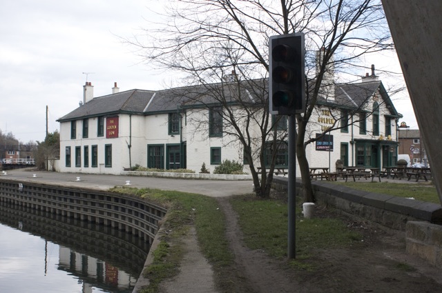
| Description |
English: The Golden Lion Public house, Ferrybridge I believe that the pub was used as a staging post for horse-drawn carriages using the Great North Road, when the only means of crossing the River Aire was by ferry. Yes, that is a traffic signal in the foreground; it is used by the coal barges entering and leaving the lock on the far left. |
| Date | |
| Source | From geograph.org.uk |
| Author | Richard Kay |
| Attribution ( required by the license) | Richard Kay / The Golden Lion Public house, Ferrybridge / |
| Camera location | | View this and other nearby images on: OpenStreetMap |
|
|---|
_heading:135.00&language=en)
| Object location | | View this and other nearby images on: OpenStreetMap |
|
|---|
_heading:135.00&language=en)
Licensing

|
This image was taken from the
Geograph project collection. See
this photograph's page on the Geograph website for the photographer's contact details. The copyright on this image is owned by Richard Kay and is licensed for reuse under the
Creative Commons Attribution-ShareAlike 2.0 license.
|
This file is licensed under the
Creative Commons
Attribution-Share Alike 2.0 Generic license.
Attribution: Richard Kay
- You are free:
- to share – to copy, distribute and transmit the work
- to remix – to adapt the work
- Under the following conditions:
- attribution – You must give appropriate credit, provide a link to the license, and indicate if changes were made. You may do so in any reasonable manner, but not in any way that suggests the licensor endorses you or your use.
- share alike – If you remix, transform, or build upon the material, you must distribute your contributions under the same or compatible license as the original.
File history
Click on a date/time to view the file as it appeared at that time.
| Date/Time | Thumbnail | Dimensions | User | Comment | |
|---|---|---|---|---|---|
| current | 20:27, 5 March 2011 |
| 640 × 425 (103 KB) | GeographBot | == {{int:filedesc}} == {{Information |description={{en|1=The Golden Lion Public house, Ferrybridge I believe that the pub was used as a staging post for horse-drawn carriages using the Great North Road, when the only means of crossing the River Aire was b |
File usage
The following pages on the English Wikipedia use this file (pages on other projects are not listed):