
Size of this preview:
800 × 407 pixels. Other resolutions:
320 × 163 pixels |
640 × 325 pixels |
1,024 × 521 pixels |
1,920 × 976 pixels.
Original file (1,920 × 976 pixels, file size: 686 KB, MIME type: image/png)
| This is a file from the
Wikimedia Commons. Information from its
description page there is shown below. Commons is a freely licensed media file repository. You can help. |
Summary
| Description |
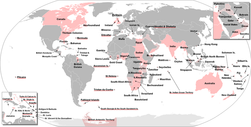
English: Areas of the world that were part of the British Empire with current British Overseas Territories underlined in red. Mandates and protected states are shown in a lighter shade. |
| Date | |
| Source | Own work |
| Author | RedStorm1368 |
Licensing
I, the copyright holder of this work, hereby publish it under the following license:
This file is licensed under the
Creative Commons
Attribution-Share Alike 4.0 International license.
- You are free:
- to share – to copy, distribute and transmit the work
- to remix – to adapt the work
- Under the following conditions:
- attribution – You must give appropriate credit, provide a link to the license, and indicate if changes were made. You may do so in any reasonable manner, but not in any way that suggests the licensor endorses you or your use.
- share alike – If you remix, transform, or build upon the material, you must distribute your contributions under the same or compatible license as the original.
File history
Click on a date/time to view the file as it appeared at that time.
| Date/Time | Thumbnail | Dimensions | User | Comment | |
|---|---|---|---|---|---|
| current | 03:19, 12 August 2023 |
| 1,920 × 976 (686 KB) | RedStorm1368 | Uploaded own work with UploadWizard |
File usage
The following pages on the English Wikipedia use this file (pages on other projects are not listed):
Global file usage
The following other wikis use this file:
- Usage on bcl.wikipedia.org
- Usage on fa.wikipedia.org