Size of this preview:
799 × 216 pixels. Other resolutions:
320 × 87 pixels |
640 × 173 pixels |
1,024 × 277 pixels |
1,280 × 346 pixels |
4,499 × 1,217 pixels.
Original file (4,499 × 1,217 pixels, file size: 982 KB, MIME type: image/jpeg)
| This is a file from the
Wikimedia Commons. Information from its
description page there is shown below. Commons is a freely licensed media file repository. You can help. |
Summary
| Description |
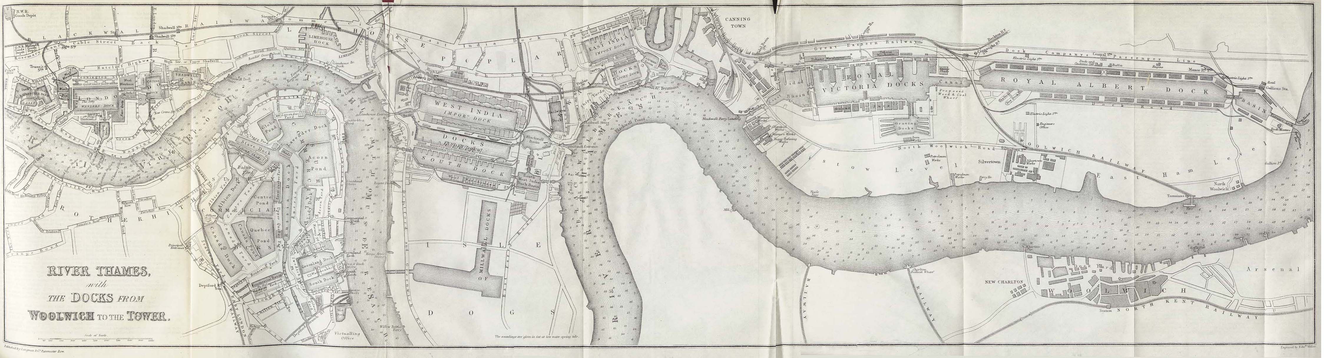
English: "River Thames with the Docks from Woolwich to the Tower" from This map shows all of the main upstream London docks except the
King George V Dock, which had not been built. It was to be located to the south of the Royal Albert Dock, which is the large dock at the far right. |
| Date | |
| Source | A Dictionary Practical, Theoretical, and Historical of Commerce and Commercial Navigation by J.R. M'Culloch - Longmans, Green and Co. London, 1882 |
| Author | Edward Weller (d. 1884) [1] |
Licensing
|
This is a faithful photographic reproduction of a two-dimensional,
public domain work of art. The work of art itself is in the public domain for the following reason:
The official position taken by the Wikimedia Foundation is that "faithful reproductions of two-dimensional public domain works of art are public domain".
This photographic reproduction is therefore also considered to be in the public domain in the United States. In other jurisdictions, re-use of this content may be restricted; see Reuse of PD-Art photographs for details. | ||||
References
File history
Click on a date/time to view the file as it appeared at that time.
| Date/Time | Thumbnail | Dimensions | User | Comment | |
|---|---|---|---|---|---|
| current | 09:36, 9 April 2006 |
| 4,499 × 1,217 (982 KB) | White-Silent-Night | "River Thames with the Docks from Woolwich to the Tower" from ''A Dictionary Practical, Theoretical, and Historical of Commerce and Commercial Navigation'' by J.R. M'Culloch. Longmans, Green and Co. London, 1882. This map shows all of the main upstream Lo |
File usage
The following pages on the English Wikipedia use this file (pages on other projects are not listed):
Global file usage
The following other wikis use this file:
- Usage on ar.wikipedia.org
- Usage on de.wikipedia.org
- Usage on eo.wikipedia.org
- Usage on es.wikipedia.org
- Usage on fr.wikipedia.org
- Usage on he.wikipedia.org
- Usage on it.wikipedia.org
- Usage on ja.wikipedia.org
- Usage on nl.wikipedia.org
- Usage on pl.wikipedia.org
- Usage on ru.wikipedia.org
- Usage on sl.wikipedia.org
- Usage on zh.wikipedia.org