
Size of this PNG preview of this SVG file:
334 × 599 pixels. Other resolutions:
134 × 240 pixels |
268 × 480 pixels |
428 × 768 pixels |
571 × 1,024 pixels |
1,142 × 2,048 pixels |
1,249 × 2,239 pixels.
Original file (SVG file, nominally 1,249 × 2,239 pixels, file size: 6.58 MB)
| This is a file from the
Wikimedia Commons. Information from its
description page there is shown below. Commons is a freely licensed media file repository. You can help. |
Summary
| Description |
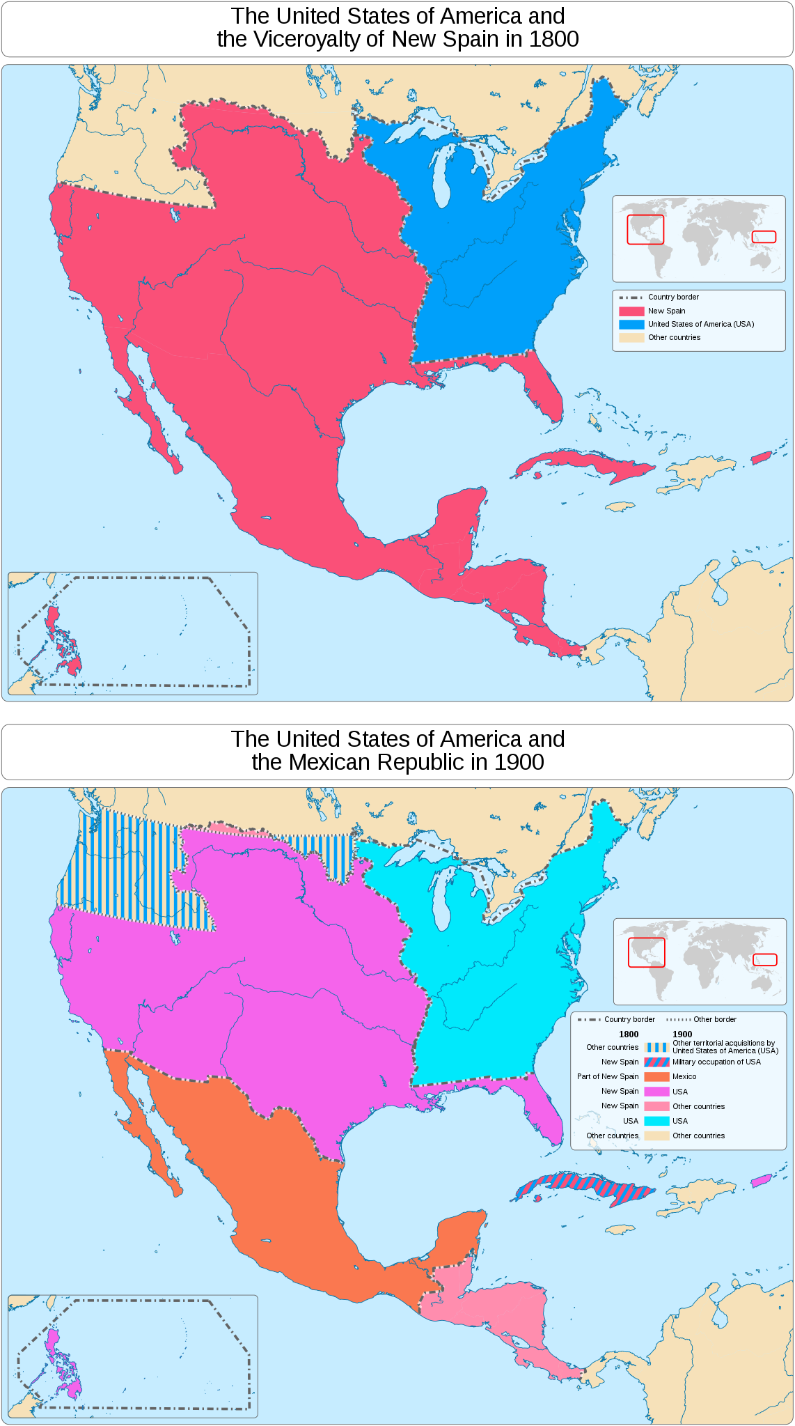
English: A map showing the territories of the Viceroyalty of New Spain in 1800 that were gradually annexed by the United States of America over the course of a century and what parts of New Spain were the Republic of Mexico only a century later.
|
||||||||||||||||||||||||||||||||||||||||||||||
| Date | |||||||||||||||||||||||||||||||||||||||||||||||
| Source |
Own work
Information from:
|
||||||||||||||||||||||||||||||||||||||||||||||
| Author | Goran_tek-en | ||||||||||||||||||||||||||||||||||||||||||||||
| Permission ( Reusing this file) |
This file is licensed under the
Creative Commons
Attribution-Share Alike 4.0 International license. Attribution: Goran tek-en
|
||||||||||||||||||||||||||||||||||||||||||||||
| Other versions |
|
||||||||||||||||||||||||||||||||||||||||||||||
| SVG development | This
vector image was created with
Inkscape. |
||||||||||||||||||||||||||||||||||||||||||||||
.svg)


_02.svg)
| Object location |
| View this and other nearby images on: OpenStreetMap |
|
|---|


_01.svg)
_01.svg¶ms=032.902099_N_-099.639074_E_globe:Earth_class:object_type:object_dim:2000km_&language=en)
File history
Click on a date/time to view the file as it appeared at that time.
| Date/Time | Thumbnail | Dimensions | User | Comment | |
|---|---|---|---|---|---|
| current | 16:38, 24 September 2021 |
| 1,249 × 2,239 (6.58 MB) | Goran tek-en | Text edit requested by Donald Trung 『徵國單』 |
| 14:13, 23 September 2021 |
 | 1,249 × 2,239 (6.58 MB) | Goran tek-en | {{Information |description ={{en|A map showing the territories of the Viceroyalty of New Spain in 1800 that were gradually annexed by the United States of America over the course of a century and what parts of New Spain were the Republic of Mexico only a century later.}} {{Institution |wikidata=Q170603}} {{Institution |wikidata=Q30}} {{Institution |wikidata=Q96}} |date =2021-09-23 |source ={{Own}}<br> {{Derived from|Viceroyalty of New Spain and the United States... |
File usage
The following pages on the English Wikipedia use this file (pages on other projects are not listed):
_01.svg)