
Original file (1,600 × 1,010 pixels, file size: 609 KB, MIME type: image/jpeg)
| This is a file from the
Wikimedia Commons. Information from its
description page there is shown below. Commons is a freely licensed media file repository. You can help. |
Summary
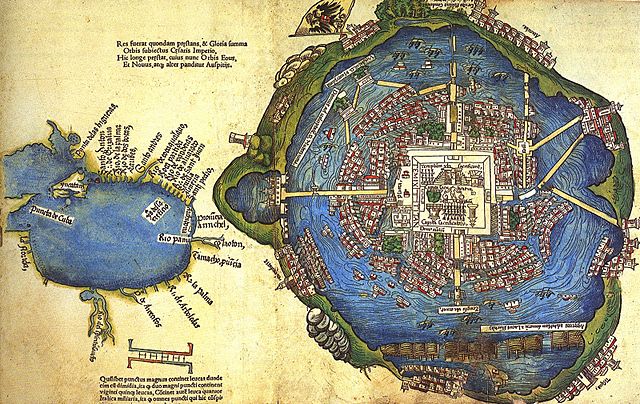
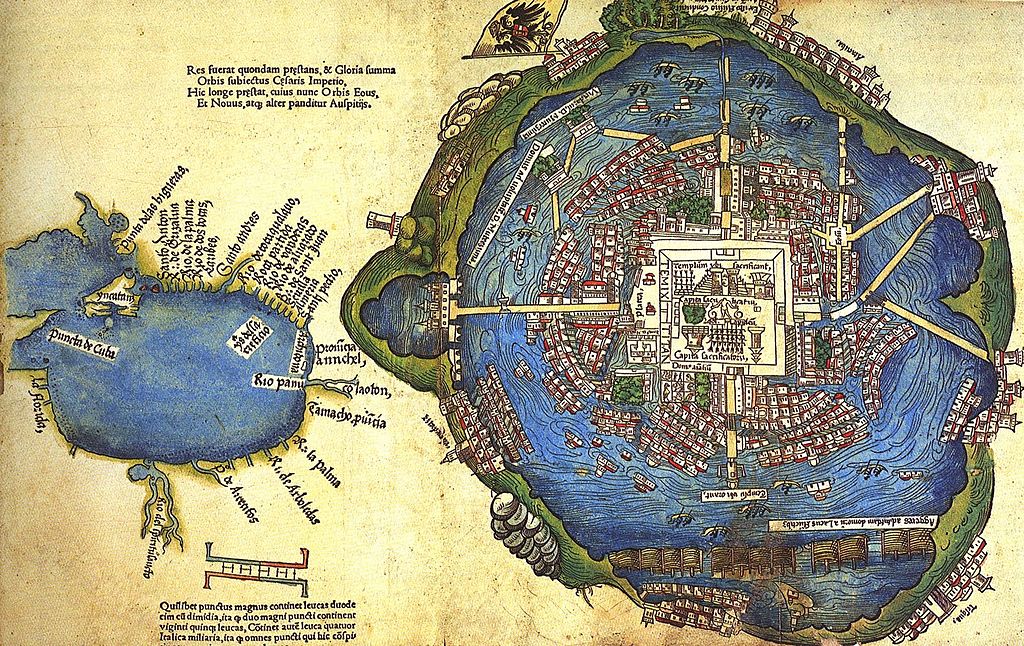
Página de «Praeclara Ferdinandi Cortesii de nova maris Oceani Hispania narratio, Sacratissimo ac Invictissimo Carolo Romanorum Imperatori Semper Augusto, Hispaniarum & Regi Anno Domini M. D. XX transmisa; ... per Doctorem Petrum Savorgnanum Foro Juliensem Reven. D. Joan. de Revelles Episco. Vienensis Secretarium ex Hispano idiomate in latinum versa Anno Domini M. D. XXIIII. KL. Martii», primera publicación de la segunda carta de Hernán Cortés al Imperador Carlos V, por Fridericum Peypus en Núremberg en 1524, tal como está conservada en la Biblioteca Newberry de Chicago.
Muestra un mapa de Tenochtitlán preparado por los Mexicas y presentado a Cortés como un regalo en el período 1519-1521, y un mapa de la región de la Costa del Golfo mexicano y la parte sureste de lo que son hoy los Estados Unidos. El autor del mapa, desconocido, pudo ser un mexica o un conquistador español, según el sitio de la Biblioteca del Congreso de Estados Unidos (véase [1]), donde se presenta otra versión, monocromática, que pertenece a la colección de grabados iluminados donados a la Biblioteca del Congreso de Estados Unidos por Lessing J. Rosenwald. (Rosenwald Collection, Rare Book and Special Collections Division).
For more information about this map, see This new world now revealed: Hernan Cortes and the presentation of Mexico to Europe, by Elizabeth Hill Boone.
Licensing
|
This is a faithful photographic reproduction of a two-dimensional,
public domain work of art. The work of art itself is in the public domain for the following reason:
The official position taken by the Wikimedia Foundation is that "faithful reproductions of two-dimensional public domain works of art are public domain". This photographic reproduction is therefore also considered to be in the public domain in the United States. In other jurisdictions, re-use of this content may be restricted; see Reuse of PD-Art photographs for details.
{{PD-Art}} template without license parameter: please specify why the underlying work is public domain in both the source country and the United States
(Usage: {{PD-Art|1=|deathyear=''year of author's death''|country=''source country''}}, where parameter #1 can be PD-old-auto, PD-old-auto-expired, PD-old-auto-1996, PD-old-100 or similar. See Commons:Multi-license copyright tags for more information.) | ||||
File history
Click on a date/time to view the file as it appeared at that time.
| Date/Time | Thumbnail | Dimensions | User | Comment | |
|---|---|---|---|---|---|
| current | 11:18, 14 June 2014 |
| 1,600 × 1,010 (609 KB) | Lupo | Even larger version from http://yesisuki.blogspot.com/2010/04/mapa-de-la-laguna-de-techtitlan.html |
| 23:19, 22 November 2012 |
 | 500 × 316 (189 KB) | Nicolas Perrault III | Better, larger version. Source: http://www.google.ca/imgres?um=1&hl=en&client=firefox-a&sa=N&tbo=d&rls=org.mozilla:en-US:official&biw=928&bih=474&tbm=isch&tbnid=mNR0I3B3z7xSPM:&imgrefurl=http://fuckyeahmexico.tumblr.com/post/35858337036/willigula-like-... | |
| 21:01, 10 May 2010 |
 | 383 × 239 (69 KB) | Uxbona | centered image | |
| 05:57, 21 April 2007 |
 | 400 × 274 (34 KB) | Maurice Marcellin~commonswiki | Página de libro publicado en 1524, perteneciente a la biblioteca Newberry de Chicago, muestra un mapa de Tenochtitlán (derecha) y un esquema del Golfo de México. Autor: un acompañante de Hernán Cortés. Category:Mexico City |
File usage
Global file usage
The following other wikis use this file:
- Usage on ar.wikipedia.org
- Usage on ca.wikipedia.org
- Usage on es.wikipedia.org
- Usage on fr.wikipedia.org
- Usage on hu.wikipedia.org
- Usage on hy.wikipedia.org
- Usage on it.wikipedia.org
- Usage on oc.wikipedia.org
- Usage on pt.wikipedia.org
- Usage on ru.wikipedia.org
- Usage on uk.wikipedia.org
- Usage on vi.wikipedia.org