
Size of this PNG preview of this SVG file:
800 × 489 pixels. Other resolutions:
320 × 196 pixels |
640 × 391 pixels |
1,024 × 626 pixels |
1,280 × 782 pixels |
2,560 × 1,564 pixels |
4,903 × 2,996 pixels.
Original file (SVG file, nominally 4,903 × 2,996 pixels, file size: 4.86 MB)
| This is a file from the
Wikimedia Commons. Information from its
description page there is shown below. Commons is a freely licensed media file repository. You can help. |
Summary
| Description |
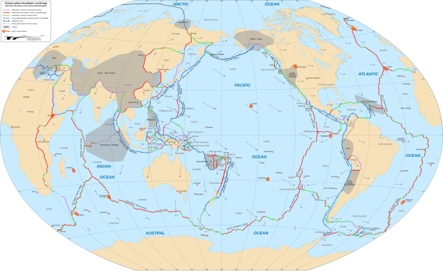
English: World map in English showing the tectonic plates boundaries with their movement vectors and selected hotspots.
Français : Carte mondiale en anglais des limites des plaques tectoniques avec leurs vecteurs de déplacement et une sélection de hotspots.
Español: Mapa en inglés que muestra las placas tectónicas con sus vectores de movimiento.
Winkel tripel projection; central longitude: 180° E |
||
| Date | |||
| Source |
|
||
| Author | Eric Gaba ( Sting - fr:Sting) | ||
| Permission ( Reusing this file) |
|
||
| Other versions |
|


|
This SVG file contains embedded text that can be translated into your language, using any capable SVG editor, text editor or the SVG Translate tool. For more information see: About translating SVG files. |
Licensing
This file is licensed under the
Creative Commons
Attribution-Share Alike 3.0 Unported license.
Attribution: "Eric Gaba for Wikimedia Commons"
- You are free:
- to share – to copy, distribute and transmit the work
- to remix – to adapt the work
- Under the following conditions:
- attribution – You must give appropriate credit, provide a link to the license, and indicate if changes were made. You may do so in any reasonable manner, but not in any way that suggests the licensor endorses you or your use.
- share alike – If you remix, transform, or build upon the material, you must distribute your contributions under the same or compatible license as the original.
File history
Click on a date/time to view the file as it appeared at that time.
| Date/Time | Thumbnail | Dimensions | User | Comment | |
|---|---|---|---|---|---|
| current | 20:38, 16 February 2018 |
| 4,903 × 2,996 (4.86 MB) | Sting | {{Information |Description={{en|World map in English showing the tectonic plates boundaries with their movement vectors and selected hotspots.}} {{fr|Carte mondiale en anglais des limites des plaques tectoniques avec leurs vecteurs de déplacement et u... |
File usage
More than 100 pages use this file. The following list shows the first 100 pages that use this file only. A full list is available.
- Abyssal plain
- Aden Ridge
- Adriatic Plate
- Aegean Sea Plate
- Aegir Ridge
- African Plate
- Alpha Ridge
- Amurian microplate
- Anatolian Sub-Plate
- Antarctic-Phoenix Ridge
- Antarctic Plate
- Arabian Plate
- Australian Plate
- Balmoral Reef Plate
- Baltic Plate
- Banda Sea Plate
- Bellingshausen Plate
- Bird's Head Plate
- Burma Plate
- Caribbean Plate
- Carlsberg Ridge
- Caroline Plate
- Central Indian Ridge
- Charcot Plate
- Cocos Plate
- Conway Reef Plate
- East Pacific Rise
- Easter Microplate
- Eurasian Plate
- Explorer Plate
- Explorer Ridge
- Farallon Plate
- Futuna Plate
- Gakkel Ridge
- Galápagos Islands
- Galápagos Microplate
- Galápagos hotspot
- Gorda Plate
- Gorda Ridge
- Greenland Plate
- Halmahera Plate
- Hotspot (geology)
- Indian Plate
- Indo-Australian Plate
- Insular Plate
- Intermontane Plate
- Iranian Plate
- Izanagi Plate
- Juan Fernández Plate
- Juan de Fuca Plate
- Juan de Fuca Ridge
- Kerguelen Plateau
- Kermadec Plate
- Kula-Farallon Ridge
- Kula Plate
- List of tectonic plates
- Madagascar Plate
- Manus Plate
- Maoke Plate
- Mariana Plate
- Mid-Atlantic Ridge
- Molucca Sea Plate
- Mountain formation
- Nazca Plate
- New Hebrides Plate
- Ninety East Ridge
- Niuafo'ou Plate
- North American Plate
- North Andes Plate
- North Bismarck Plate
- Oceanic plateau
- Okhotsk microplate
- Okinawa Plate
- Outline of plate tectonics
- Pacific-Antarctic Ridge
- Pacific-Farallon Ridge
- Pacific-Kula Ridge
- Pacific Plate
- Panama Plate
- Philippine Mobile Belt
- Philippine Sea Plate
- Phoenix Plate
- Plate tectonics
- Rivera Plate
- Scotia Plate
- Seychelles Microcontinent
- Shetland Plate
- Solomon Sea Plate
- Somali Plate
- South American Plate
- South American–Antarctic Ridge
- South Bismarck Plate
- South Sandwich Plate
- Southeast Indian Ridge
- Southwest Indian Ridge
- Subduction
- Sunda Plate
- Timor Plate
- Tonga Plate
- Woodlark Plate
View more links to this file.
Global file usage
The following other wikis use this file:
- Usage on bn.wikipedia.org
- Usage on el.wikipedia.org
- Usage on fa.wikipedia.org
- زمینساخت صفحهای
- صفحه ایران
- صفحه عربستان
- صفحه اقیانوس آرام
- صفحه آفریقا
- صفحه آمریکای شمالی
- صفحه اوراسیا
- صفحه نازکا
- صفحه آمریکای جنوبی
- صفحه جنوبگان
- صفحه خوآن دو فوکا
- صفحه استرالیا
- صفحه هند
- الگو:صفحههای زمینساختی
- شکلگیری کوه
- صفحه کارائیب
- صفحه دریای فیلیپین
- صفحه اسکوشیا
- صفحه کوکوس
- صفحه اختسک
- صفحه اوکیناوا
- صفحه کارولین
- صفحه پاناما
- صفحه آند شمالی
- صفحه بیسمارک شمالی
- صفحه ماریانا
- صفحه آناتولی
- صفحه دریای اژه
- صفحه آمورین
- صفحه دریای باندا
- صفحه ایستر
- صفحه دریای ملوک
- صفحه شتلند
- صفحه دریای سلیمان
- صفحه خوان فرناندز
View more global usage of this file.