
Size of this preview:
800 × 533 pixels. Other resolutions:
320 × 213 pixels |
640 × 427 pixels |
1,024 × 683 pixels |
1,280 × 853 pixels |
2,560 × 1,707 pixels |
4,258 × 2,839 pixels.
Original file (4,258 × 2,839 pixels, file size: 4.93 MB, MIME type: image/jpeg)
| This is a file from the
Wikimedia Commons. Information from its
description page there is shown below. Commons is a freely licensed media file repository. You can help. |
|
| This is a featured picture, which means that members of the community have identified it as one of the finest images on the English Wikipedia, adding significantly to its accompanying article. If you have a different image of similar quality, be sure to upload it using the proper free license tag, add it to a relevant article, and nominate it. |
|
| This image was selected as picture of the day on the English Wikipedia for March 16, 2021. |
| Description |
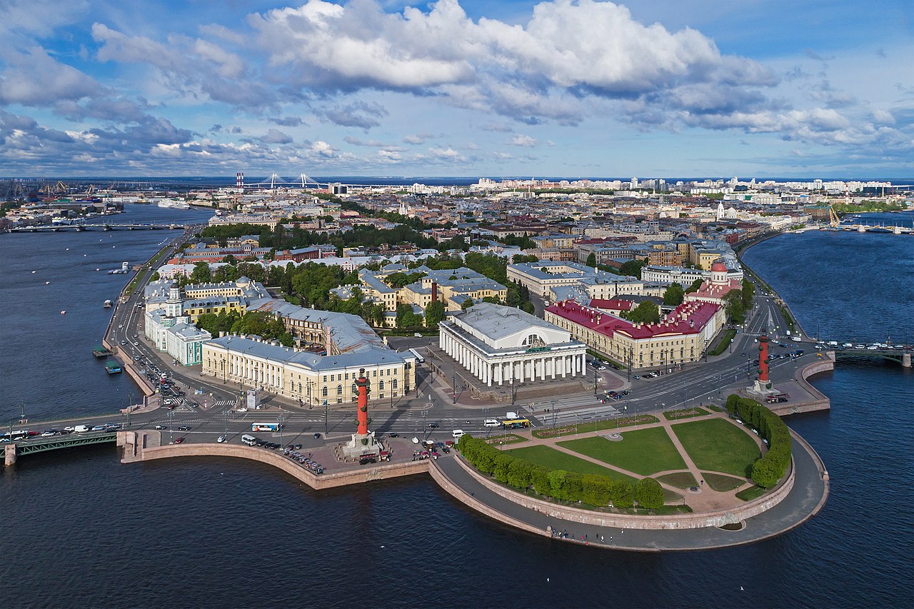
English: Aerial photo of the Vasilievsky Island Spit in Saint Petersburg (Russia).
Polski: Widok z lotu ptaka na wschodni cypel Wyspy Wasylewskiej (
ros.
Стрелка Васильевского острова) w
Petersburgu, w
Rosji.
Русский: Аэрофотосъёмка Стрелки Васильевского острова в Санкт-Петербурге (Россия).
Nederlands: Het Vasiljevski-eiland in de Russische stad
Sint-Petersburg
|
| Date | |
| Source | Own work |
| Author | A.Savin |
| Permission ( Reusing this file) |
.svg) Just attribute the author: «A.Savin, Wikipedia»; if you have questions —
Telegram, or e-mail to wikiphotospace@gmail.com..svg) Просто укажите в качестве автора: «А.Савин, Википедия»; если есть вопрос —
телеграм, или эл.почта на wikiphotospace@gmail.com. Kennzeichnen Sie einfach als Autor: «A.Savin, Wikipedia»; falls Sie Fragen haben —
Telegram, oder E-Mail an wikiphotospace@gmail.com.
Thank you. |
| Camera location |
| View this and other nearby images on: OpenStreetMap |
|
|---|
|
This image was selected as
picture of the day on Wikimedia Commons for
8 February 2019. It was captioned as follows: Other languages:
Nederlands: Het Vasiljevski-eiland in de Russische stad
Sint-Petersburg Polski: Widok z lotu ptaka na wschodni cypel Wyspy Wasylewskiej (
ros.
Стрелка Васильевского острова) w
Petersburgu, w
Rosji. |
| Annotations | This image is annotated: View the annotations at Commons |


Licensing
| Copyleft: This work of art is free; you can redistribute it and/or modify it according to terms of the Free Art License. You will find a specimen of this license on the Copyleft Attitude site as well as on other sites. |
File history
Click on a date/time to view the file as it appeared at that time.
| Date/Time | Thumbnail | Dimensions | User | Comment | |
|---|---|---|---|---|---|
| current | 00:45, 12 August 2017 |
| 4,258 × 2,839 (4.93 MB) | A.Savin | {{User:A.Savin/F |Description= {{en|Aerial photo of the Vasilievsky Island Spit in Saint Petersburg (Russia).}} {{ru|Аэрофотосъёмка Стрелки Васильевского острова в Санкт-Петербурге (Россия)... |
File usage
The following pages on the English Wikipedia use this file (pages on other projects are not listed):
- Administrative divisions of Saint Petersburg
- Baltic Sea
- Demographics of Russia
- Eurasian Economic Union
- Geography of Russia
- List of cities and towns around the Baltic Sea
- List of cities and towns in Russia by population
- Metropolis
- Municipal Okrug 7
- Old Saint Petersburg Stock Exchange and Rostral Columns
- Outline of Saint Petersburg
- Russia
- Urban area
- Vasilyevsky Island
- Talk:Saint Petersburg
- User:Cote d'Azur/sandbox
- User:Desutch2/Russia
- User:Pimajor/sandbox
- User:Seryo93/Russia
- User talk:A.Savin
- User talk:MER-C/archives/44
- Wikipedia:Featured picture candidates/May-2019
- Wikipedia:Featured picture candidates/Vasilievsky Island
- Wikipedia:Featured pictures/Places/Urban
- Wikipedia:Featured pictures thumbs/64
- Wikipedia:Main Page history/2021 March 16
- Wikipedia:Main Page history/2021 March 16b
- Wikipedia:Picture of the day/March 2021
- Wikipedia:WikiProject Islands/Recognized content
- Wikipedia:WikiProject Russia/Human geography of Russia task force
- Wikipedia:WikiProject Russia/Physical geography of Russia task force
- Wikipedia:WikiProject Russia/Recognized content
- Template:Largest cities of Russia
- Template:POTD/2021-03-16
- Portal:Architecture/Recognized content
- Portal:Russia/Selected picture
- Portal:The arts/Recognized content
Global file usage
The following other wikis use this file:
- Usage on af.wikipedia.org
- Usage on ar.wikipedia.org
- Usage on azb.wikipedia.org
- Usage on ba.wikipedia.org
- Usage on be-tarask.wikipedia.org
- Usage on be.wikipedia.org
- Usage on bh.wikipedia.org
- Usage on bn.wikipedia.org
- Usage on bxr.wikipedia.org
- Usage on ca.wikipedia.org
- Usage on ceb.wikipedia.org
- Usage on ckb.wikipedia.org
- Usage on crh.wikipedia.org
- Usage on cs.wikipedia.org
- Usage on cv.wikipedia.org
- Usage on de.wikipedia.org
- Usage on el.wikipedia.org
- Usage on en.wikivoyage.org
- Usage on eo.wikipedia.org
- Usage on es.wikipedia.org
- Usage on et.wikipedia.org
- Usage on et.wikiquote.org
- Usage on fa.wikipedia.org
- Usage on fi.wikipedia.org
- Usage on fr.wikipedia.org
- Usage on gl.wikipedia.org
- Usage on ha.wikipedia.org
View more global usage of this file.