No higher resolution available.
Southern_United_States_Civil_War_map.png (566 × 365 pixels, file size: 6 KB, MIME type: image/png)
| This is a file from the
Wikimedia Commons. Information from its
description page there is shown below. Commons is a freely licensed media file repository. You can help. |

|
This historical map image could be re-created using
vector graphics as an
SVG file. This has several advantages; see
Commons:Media for cleanup for more information. If an SVG form of this image is available, please upload it and afterwards replace this template with
{{
vector version available|new image name}}
.
It is recommended to name the SVG file “Southern United States Civil War map.svg”—then the template Vector version available (or Vva) does not need the new image name parameter. |
Summary
| Description |
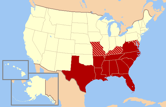
English: Historic map of Southern United States, based on Civil War allegiances. The states in solid red seceded from the Union to form the Confederate States of America, while the striped states - Missouri, Kentucky, Maryland, and Delaware - were "Border States," slave states that did not secede from the Union to join the Confederacy. Oklahoma (not yet a state) was then Indian Territory. The Northern Counties of Virginia chose to remain in the Union and in 1863 became the state of West Virginia. |
| Source | Own work |
| Author | Gator87 |
Licensing
I, the copyright holder of this work, hereby publish it under the following license:

|
Permission is granted to copy, distribute and/or modify this document under the terms of the GNU Free Documentation License, Version 1.2 or any later version published by the Free Software Foundation; with no Invariant Sections, no Front-Cover Texts, and no Back-Cover Texts. A copy of the license is included in the section entitled GNU Free Documentation License. |
| This file is licensed under the Creative Commons Attribution-Share Alike 3.0 Unported license. | ||
| ||
| This licensing tag was added to this file as part of the GFDL licensing update. |
File history
Click on a date/time to view the file as it appeared at that time.
| Date/Time | Thumbnail | Dimensions | User | Comment | |
|---|---|---|---|---|---|
| current | 22:13, 13 June 2010 |
| 566 × 365 (6 KB) | Ras67 | cropped |
| 02:53, 11 February 2007 |
 | 572 × 371 (19 KB) | Gator87~commonswiki | Map of Historic Southern United States. States in red were in the Confederacy, whereas the striped states - Missouri, Kentucky, Maryland, and Delaware - were considered "Border States" that remained in the Union, though they gave varying degrees of suppo |
File usage
No pages on the English Wikipedia use this file (pages on other projects are not listed).
Global file usage
The following other wikis use this file:
- Usage on eu.wikipedia.org
- Usage on nl.wikipedia.org
- Usage on simple.wikipedia.org
- Usage on vi.wikipedia.org
- Usage on zh.wikipedia.org