No higher resolution available.
Semreservation.jpg (229 × 325 pixels, file size: 20 KB, MIME type: image/jpeg)
| This is a file from the
Wikimedia Commons. Information from its
description page there is shown below. Commons is a freely licensed media file repository. You can help. |
| Description |
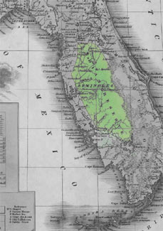
English: Reservation land of the Seminoles in the 1820s and 1830s. Published in 1831 by A. Finley Philadelphia in A New General Atlas Comprising a Complete Set of Maps, representing the Grand Divisions Of The Globe. David Rumsey Map Collection.
Downloaded from http://www.johnhorse.com/trail/01/c/08.htm Originally published in 1831:
|
| Source | see above |
| Author | Anthony Finley |
Licensing
This media file is in the
public domain in the
United States. This applies to U.S. works where the copyright has expired, often because its first
publication occurred prior to January 1, 1929, and if not then due to lack of notice or renewal. See
this page for further explanation.
|
 | |
 |
This image might not be in the public domain outside of the United States; this especially applies in the countries and areas that do not apply the
rule of the shorter term for US works, such as Canada, Mainland China (not Hong Kong or Macao), Germany, Mexico, and Switzerland. The creator and year of publication are essential information and must be provided. See
Wikipedia:Public domain and
Wikipedia:Copyrights for more details.
|
Original upload log
The original description page was
here. All following user names refer to en.wikipedia.
- 2006-10-21 18:04 Donald Albury 229×325× (20506 bytes) Downloaded from http://www.johnhorse.com/trail/01/c/08.htm Published in 1831 by A. Finley Philadelphia in ''A New General Atlas Comprising a Complete Set of Maps, representing the Grand Divisions Of The Globe''.
File history
Click on a date/time to view the file as it appeared at that time.
| Date/Time | Thumbnail | Dimensions | User | Comment | |
|---|---|---|---|---|---|
| current | 23:06, 25 March 2009 |
| 229 × 325 (20 KB) | Poisend-Ivy | {{Information |Description={{en|Reservation land of the Seminoles in the 1820s and 1830s. Published in 1831 by A. Finley Philadelphia in A New General Atlas Comprising a Complete Set of Maps, representing the Grand Divisions Of The Globe. David Rumsey Ma |
File usage
The following pages on the English Wikipedia use this file (pages on other projects are not listed):
Global file usage
The following other wikis use this file:
- Usage on ca.wikipedia.org
- Usage on de.wikipedia.org
- Usage on fr.wikipedia.org