
Size of this preview:
800 × 260 pixels. Other resolutions:
320 × 104 pixels |
1,002 × 326 pixels.
Original file (1,002 × 326 pixels, file size: 556 KB, MIME type: image/jpeg)
| This is a file from the
Wikimedia Commons. Information from its
description page there is shown below. Commons is a freely licensed media file repository. You can help. |

|
This map image could be re-created using
vector graphics as an
SVG file. This has several advantages; see
Commons:Media for cleanup for more information. If an SVG form of this image is available, please upload it and afterwards replace this template with
{{
vector version available|new image name}}
.
It is recommended to name the SVG file “Scenes and approximate times of events of April 18-19.svg”—then the template Vector version available (or Vva) does not need the new image name parameter. |


Summary
| Description |
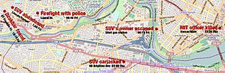
English: Scenes and approximate times of events of April 18-19 |
| Date | |
| Source | OpenStreetMap |
| Author | OpenStreetMap |
Licensing
|
|
This work contains information from
OpenStreetMap, which is made available under the
Open Database License (ODbL).
The ODbL does not require any particular license for maps produced from ODbL data. Prior to 1 August 2020, map tiles produced by the OpenStreetMap Foundation were licensed under the CC-BY-SA-2.0 license. Maps produced by other people may be subject to other licences. |
File history
Click on a date/time to view the file as it appeared at that time.
| Date/Time | Thumbnail | Dimensions | User | Comment | |
|---|---|---|---|---|---|
| current | 08:28, 19 May 2013 |
| 1,002 × 326 (556 KB) | Laura Weintraub | Bigger resolution. |
| 18:09, 18 May 2013 |
| 600 × 195 (47 KB) | Laura Weintraub | User created page with UploadWizard |
File usage
The following pages on the English Wikipedia use this file (pages on other projects are not listed):