
Size of this preview:
398 × 599 pixels. Other resolutions:
159 × 240 pixels |
319 × 480 pixels |
510 × 768 pixels |
680 × 1,024 pixels |
1,360 × 2,048 pixels |
2,848 × 4,288 pixels.
Original file (2,848 × 4,288 pixels, file size: 8.47 MB, MIME type: image/jpeg)
| This is a file from the
Wikimedia Commons. Information from its
description page there is shown below. Commons is a freely licensed media file repository. You can help. |
Summary
| Description |
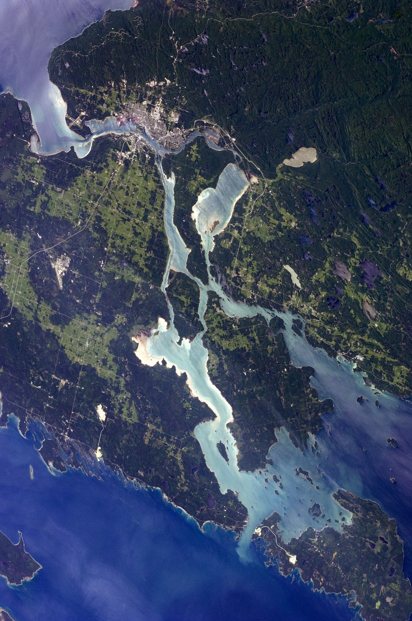
English: The twin cities of Sault Ste Marie are located across the
St. Mary’s River, which forms part of the international boundary between Canada (Province of Ontario) and the United States (State of Michigan). This astronaut photograph highlights the two cities, as well as the lakes and islands that separate
Lakes Huron and
Superior, two of the
Great Lakes of North America. Smaller lakes include Lake George to the west, and the large forested islands of St. Joseph and Drummond are visible at image upper left.
The Sault Ste Marie urban areas (image lower left) have a distinctive
gray to
white colour, contrasting with the deep
green of forested areas in Ontario and the lighter green of agricultural fields in Michigan. The
water surfaces in the lakes and rivers vary from
blue to blue-green to
silver, likely the result of varying degrees of sediment and
sunglint—
light reflecting from the water surface back to the
International Space Station. |
| Date | |
| Source | NASA Earth Observatory |
| Author | ISS Expedition 28 crew |
| Camera location |
| View this and other nearby images on: OpenStreetMap |
|
|---|
This image or video was catalogued by Johnson Space Center of the United States
National Aeronautics and Space Administration (NASA) under Photo ID:
ISS028-E-10162. This tag does not indicate the copyright status of the attached work. A normal copyright tag is still required. See Commons:Licensing. Other languages:
|
Image acquired with a Nikon D2Xs digital camera using a 110 mm lens, and is provided by the ISS Crew Earth Observations experiment and Image Science & Analysis Laboratory, Johnson Space Center.
Licensing
| This file is in the public domain in the United States because it was solely created by NASA. NASA copyright policy states that "NASA material is not protected by copyright unless noted". (See Template:PD-USGov, NASA copyright policy page or JPL Image Use Policy.) | ||
 |
Warnings:
|
| Annotations | This image is annotated: View the annotations at Commons |
File history
Click on a date/time to view the file as it appeared at that time.
| Date/Time | Thumbnail | Dimensions | User | Comment | |
|---|---|---|---|---|---|
| current | 12:12, 18 August 2018 |
| 2,848 × 4,288 (8.47 MB) | Ras67 | new rendered from NASA's raw image date with real quality and without clipped highlights |
| 20:48, 23 February 2013 |
 | 2,848 × 4,288 (12.03 MB) | Rotatebot | Bot: Image rotated by 90° | |
| 12:20, 11 July 2011 |
 | 4,288 × 2,848 (10.92 MB) | Originalwana | {{Information |Description ={{en|1=The twin cities of Sault Ste Marie are located across the St. Mary’s River, which forms part of the international boundary between Canada (Province of Ontario) and the United S |
File usage
The following pages on the English Wikipedia use this file (pages on other projects are not listed):
Global file usage
The following other wikis use this file:
- Usage on ar.wikipedia.org
- Usage on el.wikipedia.org
- Usage on et.wikipedia.org
- Usage on fa.wikipedia.org
- Usage on fi.wikipedia.org
- Usage on it.wikipedia.org
- Usage on nl.wikipedia.org