
Size of this preview:
600 × 600 pixels. Other resolutions:
240 × 240 pixels |
480 × 480 pixels |
900 × 900 pixels.
Original file (900 × 900 pixels, file size: 735 KB, MIME type: image/jpeg)
| This is a file from the
Wikimedia Commons. Information from its
description page there is shown below. Commons is a freely licensed media file repository. You can help. |
| Description |
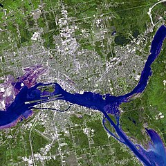
Satellite image of the St. Marys River — in Michigan (U.S.) and Ontario (Canada).
|
| Date | |
| Source | NASA/GSFC/METI/ERSDAC/JAROS and U.S./Japan ASTER Science Team |
| Author | NASA |
| Other versions | http://asterweb.jpl.nasa.gov/gallery-detail.asp?name=Saultste |
| This file is in the public domain in the United States because it was solely created by NASA. NASA copyright policy states that "NASA material is not protected by copyright unless noted". (See Template:PD-USGov, NASA copyright policy page or JPL Image Use Policy.) | ||
 |
Warnings:
|
File history
Click on a date/time to view the file as it appeared at that time.
| Date/Time | Thumbnail | Dimensions | User | Comment | |
|---|---|---|---|---|---|
| current | 00:19, 10 February 2010 |
| 900 × 900 (735 KB) | Scewing | {{Information |Description=Sault Ste. Marie satellite image acquired June 10, 2007 |Source=NASA/GSFC/METI/ERSDAC/JAROS and U.S./Japan ASTER Science Team |Date=2007-06-10 |Author=NASA |Permission=see below |other_versions=http://asterweb.jpl.nasa.gov/galle |
File usage
The following pages on the English Wikipedia use this file (pages on other projects are not listed):
Global file usage
The following other wikis use this file:
- Usage on ar.wikipedia.org
- Usage on de.wikipedia.org
- Usage on fa.wikipedia.org
- Usage on fr.wikipedia.org
- Usage on fy.wikipedia.org
- Usage on ru.wikipedia.org