
Size of this preview:
800 × 571 pixels. Other resolutions:
320 × 228 pixels |
640 × 457 pixels |
1,024 × 731 pixels |
1,280 × 913 pixels |
2,560 × 1,827 pixels |
3,756 × 2,680 pixels.
Original file (3,756 × 2,680 pixels, file size: 3.37 MB, MIME type: image/jpeg)
| This is a file from the
Wikimedia Commons. Information from its
description page there is shown below. Commons is a freely licensed media file repository. You can help. |
Summary
| Description |
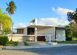
English: The historic Santuario Nacional Martín de Porres (built 1951), located on Oeste Cementerio Street in
Cataño,
Puerto Rico, is listed on the U.S. National Register of Historic Places under its original English name of Sanctuary of Blessed Martín de Porres. |
| Date | |
| Source | Own work |
| Author | Ian Poellet |
| Camera location | | View this and other nearby images on: OpenStreetMap |
|
|---|
Licensing
I, the copyright holder of this work, hereby publish it under the following license:
This file is licensed under the
Creative Commons
Attribution-Share Alike 4.0 International license.
- You are free:
- to share – to copy, distribute and transmit the work
- to remix – to adapt the work
- Under the following conditions:
- attribution – You must give appropriate credit, provide a link to the license, and indicate if changes were made. You may do so in any reasonable manner, but not in any way that suggests the licensor endorses you or your use.
- share alike – If you remix, transform, or build upon the material, you must distribute your contributions under the same or compatible license as the original.
File history
Click on a date/time to view the file as it appeared at that time.
| Date/Time | Thumbnail | Dimensions | User | Comment | |
|---|---|---|---|---|---|
| current | 02:42, 7 April 2017 |
| 3,756 × 2,680 (3.37 MB) | Ipoellet | User created page with UploadWizard |
File usage
The following pages on the English Wikipedia use this file (pages on other projects are not listed):