No higher resolution available.
Salt_River_Canyon_Bridges.jpg (499 × 331 pixels, file size: 54 KB, MIME type: image/jpeg)
| This is a file from the
Wikimedia Commons. Information from its
description page there is shown below. Commons is a freely licensed media file repository. You can help. |
Summary
|
This is an image of a place or building that is listed on the
National Register of Historic Places in the
United States of America. Its reference number is
88001608. |
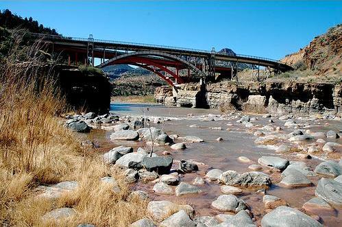
| Description | Bridgepixing the Salt River Canyon Bridges, aka Apache Bridges, 130 miles northeast of Phoenix. In the foreground, the historic arch bridge, now a pedestrian only bridge, and behind it, the new modern arch bridge. This is a famous historical site where Native Americans lived before the arrival of Spanish explorers. Additional Bridge Photos and Bridge Blog at www.Bridgepix.com. |
| Date | |
| Source | Salt River Canyon Bridges, Arizona |
| Author | Thad Roan from Littleton, CO, USA |
| Permission ( Reusing this file) |
Picture on Flickr is "all rights reserved" but CC-BY-SA licensing has been agreed to for a lower resolution file. |
| Camera location |
| View this and other nearby images on: OpenStreetMap |
|
|---|
Licensing
This file is licensed under the
Creative Commons
Attribution-Share Alike 2.0 Generic license.
- You are free:
- to share – to copy, distribute and transmit the work
- to remix – to adapt the work
- Under the following conditions:
- attribution – You must give appropriate credit, provide a link to the license, and indicate if changes were made. You may do so in any reasonable manner, but not in any way that suggests the licensor endorses you or your use.
- share alike – If you remix, transform, or build upon the material, you must distribute your contributions under the same or compatible license as the original.
File history
Click on a date/time to view the file as it appeared at that time.
| Date/Time | Thumbnail | Dimensions | User | Comment | |
|---|---|---|---|---|---|
| current | 20:13, 4 August 2009 |
| 499 × 331 (54 KB) | Holly Cheng | {{Information |Description= Bridgepixing the '''Salt River Canyon Bridges''', aka '''Apache Bridges''', 130 miles northeast of Phoenix. In the foreground, the historic arch bridge, now a pedestrian only bridge, and behind it, the new modern arch bridge. T |
File usage
The following pages on the English Wikipedia use this file (pages on other projects are not listed):
Global file usage
The following other wikis use this file:
- Usage on fr.wikipedia.org