
Size of this preview:
634 × 599 pixels. Other resolutions:
254 × 240 pixels |
508 × 480 pixels |
982 × 928 pixels.
Original file (982 × 928 pixels, file size: 21 KB, MIME type: image/png)
| This is a file from the
Wikimedia Commons. Information from its
description page there is shown below. Commons is a freely licensed media file repository. You can help. |
Summary
| Description |
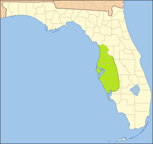
English: Map of the approximate area of the Safety Harbor archaeological culture, based on the map on page 390 in Milanich, Jerald T. (1994). Archaeology of Precolumbian Florida. Gainesville, Florida: University Press of Florida.
ISBN
0-8130-1273-2. |
| Date | |
| Source |
taken from US Census website
[1] as modified by
User:Ruhrfisch at
 |
| Author | US Census, Ruhrfisch, Donald Albury |
| Permission ( Reusing this file) |
US Census / US Government work is public domain, my modifications licensed under the CC BY-SA 4.0 License |
Licensing
I, the copyright holder of this work, hereby publish it under the following license:
This file is licensed under the
Creative Commons
Attribution-Share Alike 4.0 International license.
- You are free:
- to share – to copy, distribute and transmit the work
- to remix – to adapt the work
- Under the following conditions:
- attribution – You must give appropriate credit, provide a link to the license, and indicate if changes were made. You may do so in any reasonable manner, but not in any way that suggests the licensor endorses you or your use.
- share alike – If you remix, transform, or build upon the material, you must distribute your contributions under the same or compatible license as the original.
File history
Click on a date/time to view the file as it appeared at that time.
| Date/Time | Thumbnail | Dimensions | User | Comment | |
|---|---|---|---|---|---|
| current | 02:33, 4 January 2015 |
| 982 × 928 (21 KB) | Donald Albury | User created page with UploadWizard |
File usage
The following pages on the English Wikipedia use this file (pages on other projects are not listed):
Global file usage
The following other wikis use this file:
- Usage on de.wikipedia.org
- Usage on es.wikipedia.org