Size of this preview:
426 × 599 pixels. Other resolutions:
171 × 240 pixels |
582 × 818 pixels.
Original file (582 × 818 pixels, file size: 43 KB, MIME type: image/png)
| This is a file from the
Wikimedia Commons. Information from its
description page there is shown below. Commons is a freely licensed media file repository. You can help. |
Summary
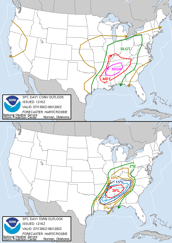
| Description | Probabilistic maps issued by the en:Storm Prediction Center during the heart of the en:April 6-8, 2006 Tornado Outbreak. |
| Date | April 7, 2006; uploaded August 31, 2006 |
| Source | SPC archives. Originally uploaded at en.wikipedia; description page is/was here. |
| Author | Storm Prediction Center, NWS |
Licensing
This image is in the
public domain because it contains materials that originally came from the U.S.
National Oceanic and Atmospheric Administration, taken or made as part of an employee's official duties.
|
Original upload log
(All user names refer to en.wikipedia)
- 2006-08-31 19:59 Runningonbrains 582×818×8 (43575 bytes) == Summary == [[probability|Probabilistic]] maps issued by the [[Storm Prediction Center]] during the heart of the [[April 6-8, 2006 Tornado Outbreak]]. Source: [http://www.spc.noaa.gov/products/outlook/archive/2006/day1otlk_20060407_1300.html SPC archiv
File history
Click on a date/time to view the file as it appeared at that time.
| Date/Time | Thumbnail | Dimensions | User | Comment | |
|---|---|---|---|---|---|
| current | 15:34, 23 September 2007 |
| 582 × 818 (43 KB) | Carlos-X | {{Information |Description= Probabilistic maps issued by the en:Storm Prediction Center during the heart of the en:April 6-8, 2006 Tornado Outbreak. Source: [http://www.spc.noaa.gov/products/outlook/archive/2006/day1otlk_2006 |
File usage
The following pages on the English Wikipedia use this file (pages on other projects are not listed):
Global file usage
The following other wikis use this file:
- Usage on ast.wikipedia.org
- Usage on de.wikipedia.org
- Usage on es.wikipedia.org
- Usage on fr.wikipedia.org
- Usage on gl.wikipedia.org