
Size of this preview:
800 × 428 pixels. Other resolutions:
320 × 171 pixels |
640 × 343 pixels |
1,024 × 548 pixels |
1,280 × 685 pixels |
1,920 × 1,028 pixels.
Original file (1,920 × 1,028 pixels, file size: 671 KB, MIME type: image/png)
| This is a file from the
Wikimedia Commons. Information from its
description page there is shown below. Commons is a freely licensed media file repository. You can help. |
Summary
| Description |
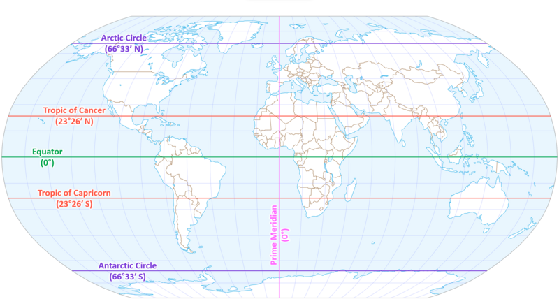
English: This is a world map in the Robinson projection with the five major circles of latitude (Arctic Circle, Tropic of Cancer, Equator, Tropic of Capricorn, and Antarctic Circle) and the Prime Meridian (Greenwich Meridian) identified by colored lines and text labels including their coordinate locations in degrees minutes. This image is adapted from
File:Equator,_tropics_and_polar_circles.svg, from which I borrowed the colored lines and the map itself. All I did was add labels near the lines.
Español: Este es un mapa mundial en la proyección de Robinson, con los cinco círculos principales de latitud (el Círculo Ártico, el Trópico de Cáncer, el Ecuador, el Trópico de Capricornio y el Círculo Antártico) y el Primer Meridiano (Meridiano de Greenwich) identificados por líneas de colores y etiquetas de texto que incluyen sus coordenadas en grados y minutos. Esta imagen fue adaptada de
File:Equator,_tropics_and_polar_circles.svg, del cual tomé prestadas las líneas coloreadas y el mapa mismo. Todo lo que hice fue agregar etiquetas cerca de las líneas. |
| Date | |
| Source | Own work |
| Author | PJsg1011 |
Licensing
I, the copyright holder of this work, hereby publish it under the following license:
This file is licensed under the
Creative Commons
Attribution-Share Alike 4.0 International license.
- You are free:
- to share – to copy, distribute and transmit the work
- to remix – to adapt the work
- Under the following conditions:
- attribution – You must give appropriate credit, provide a link to the license, and indicate if changes were made. You may do so in any reasonable manner, but not in any way that suggests the licensor endorses you or your use.
- share alike – If you remix, transform, or build upon the material, you must distribute your contributions under the same or compatible license as the original.
File history
Click on a date/time to view the file as it appeared at that time.
| Date/Time | Thumbnail | Dimensions | User | Comment | |
|---|---|---|---|---|---|
| current | 04:08, 5 January 2024 |
| 1,920 × 1,028 (671 KB) | PJsg1011 | larger font size for labels |
| 03:55, 5 January 2024 |
 | 1,920 × 1,029 (650 KB) | PJsg1011 | Uploaded own work with UploadWizard |
File usage
The following pages on the English Wikipedia use this file (pages on other projects are not listed):