
Size of this PNG preview of this SVG file:
753 × 600 pixels. Other resolutions:
302 × 240 pixels |
603 × 480 pixels |
965 × 768 pixels |
1,280 × 1,019 pixels |
2,560 × 2,038 pixels |
849 × 676 pixels.
Original file (SVG file, nominally 849 × 676 pixels, file size: 634 KB)
| This is a file from the
Wikimedia Commons. Information from its
description page there is shown below. Commons is a freely licensed media file repository. You can help. |
| Description |
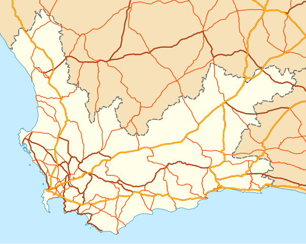
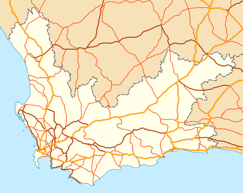
English: Map of the
Western Cape with national roads, major regional roads and minor regional roads. |
| Date | |
| Source | Geodata from OpenStreetMap |
| Author | Adrian Frith; OpenStreetMap contributors |
| Permission ( Reusing this file) |
This file is licensed under the
Creative Commons
Attribution-Share Alike 2.0 Generic license.
|
| Other versions | File:Road map of the Western Cape with towns.svg |
File history
Click on a date/time to view the file as it appeared at that time.
| Date/Time | Thumbnail | Dimensions | User | Comment | |
|---|---|---|---|---|---|
| current | 20:10, 16 June 2011 |
| 849 × 676 (634 KB) | Htonl | {{Information |Description ={{en|1=Map of the w:Western Cape with national roads, major regional roads and minor regional roads.}} |Source =Geodata from OpenStreetMap |Author = Adrian Frith; Op |
File usage
The following pages on the English Wikipedia use this file (pages on other projects are not listed):
- N12 (South Africa)
- N1 (South Africa)
- N2 (South Africa)
- N7 (South Africa)
- N9 (South Africa)
- R101 (South Africa)
- R102 (South Africa)
- R27 (South Africa)
- R300 (South Africa)
- R301 (South Africa)
- R302 (South Africa)
- R303 (South Africa)
- R304 (South Africa)
- R305 (South Africa)
- R307 (South Africa)
- R310 (South Africa)
- R311 (South Africa)
- R312 (South Africa)
- R315 (South Africa)
- R316 (South Africa)
- R317 (South Africa)
- R318 (South Africa)
- R319 (South Africa)
- R320 (South Africa)
- R321 (South Africa)
- R322 (South Africa)
- R323 (South Africa)
- R324 (South Africa)
- R326 (South Africa)
- R327 (South Africa)
- R328 (South Africa)
- R339 (South Africa)
- R340 (South Africa)
- R341 (South Africa)
- R353 (South Africa)
- R354 (South Africa)
- R355 (South Africa)
- R356 (South Africa)
- R358 (South Africa)
- R362 (South Africa)
- R363 (South Africa)
- R364 (South Africa)
- R365 (South Africa)
- R366 (South Africa)
- R381 (South Africa)
- R399 (South Africa)
- R402 (South Africa)
- R404 (South Africa)
- R406 (South Africa)
- R407 (South Africa)
- R43 (South Africa)
- R44 (South Africa)
- R45 (South Africa)
- R46 (South Africa)
- R60 (South Africa)
- R61 (South Africa)
- R62 (South Africa)
- R63 (South Africa)
- Template:Western Cape highways
Global file usage
The following other wikis use this file:
- Usage on af.wikipedia.org
- N1 (Suid-Afrika)
- N2 (Suid-Afrika)
- N7 (Suid-Afrika)
- N9 (Suid-Afrika)
- N12 (Suid-Afrika)
- R101 (Suid-Afrika)
- R102 (Suid-Afrika)
- Sjabloon:Genommerde roetes in die Wes-Kaap
- R300 (Suid-Afrika)
- R301 (Suid-Afrika)
- R302 (Suid-Afrika)
- R303 (Suid-Afrika)
- R304 (Suid-Afrika)
- R305 (Suid-Afrika)
- R306 (Suid-Afrika)
- R307 (Suid-Afrika)
- R310 (Suid-Afrika)
- R311 (Suid-Afrika)
- R312 (Suid-Afrika)
- R315 (Suid-Afrika)
- R316 (Suid-Afrika)
- R317 (Suid-Afrika)
- R318 (Suid-Afrika)
- R319 (Suid-Afrika)
- R320 (Suid-Afrika)
- R321 (Suid-Afrika)
- R322 (Suid-Afrika)
- R323 (Suid-Afrika)
- R324 (Suid-Afrika)
- R326 (Suid-Afrika)
- R327 (Suid-Afrika)
- R328 (Suid-Afrika)
- R339 (Suid-Afrika)
- R340 (Suid-Afrika)
- R341 (Suid-Afrika)
- R353 (Suid-Afrika)
- R354 (Suid-Afrika)
- R355 (Suid-Afrika)
- R356 (Suid-Afrika)
- R358 (Suid-Afrika)
- R362 (Suid-Afrika)
- R363 (Suid-Afrika)
- R364 (Suid-Afrika)
- R365 (Suid-Afrika)
- R366 (Suid-Afrika)
- R381 (Suid-Afrika)
- R399 (Suid-Afrika)
- R404 (Suid-Afrika)
- R406 (Suid-Afrika)
- R407 (Suid-Afrika)
View more global usage of this file.