
Size of this PNG preview of this SVG file:
800 × 567 pixels. Other resolutions:
320 × 227 pixels |
640 × 453 pixels |
1,024 × 725 pixels |
1,280 × 907 pixels |
2,560 × 1,813 pixels |
2,400 × 1,700 pixels.
Original file (SVG file, nominally 2,400 × 1,700 pixels, file size: 142 KB)
| This is a file from the
Wikimedia Commons. Information from its
description page there is shown below. Commons is a freely licensed media file repository. You can help. |
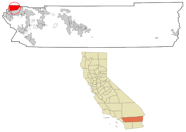
| Description | This map shows the incorporated and unincorporated areas in Riverside County, California, highlighting Jurupa Valley in red. It was created with a custom script with US Census Bureau data and modified with Inkscape. |
| Date | (UTC) |
| Source | |
| Author | |
| Other versions | Derivative works of this file: Riverside County California Incorporated and Unincorporated areas Eastvale Highlighted.svg |
I, the copyright holder of this work, hereby publish it under the following licenses:
This file is licensed under the
Creative Commons Attribution-Share Alike
2.5 Generic,
2.0 Generic and
1.0 Generic license.
- You are free:
- to share – to copy, distribute and transmit the work
- to remix – to adapt the work
- Under the following conditions:
- attribution – You must give appropriate credit, provide a link to the license, and indicate if changes were made. You may do so in any reasonable manner, but not in any way that suggests the licensor endorses you or your use.
- share alike – If you remix, transform, or build upon the material, you must distribute your contributions under the same or compatible license as the original.
| This file is licensed under the Creative Commons Attribution-Share Alike 3.0 Unported license. | ||
| ||
| This licensing tag was added to this file as part of the GFDL licensing update. |

|
Permission is granted to copy, distribute and/or modify this document under the terms of the GNU Free Documentation License, Version 1.2 or any later version published by the Free Software Foundation; with no Invariant Sections, no Front-Cover Texts, and no Back-Cover Texts. A copy of the license is included in the section entitled GNU Free Documentation License. |
You may select the license of your choice.
Original upload log
This image is a derivative work of the following images:
-
File:Riverside_County_California_Incorporated_and_Unincorporated_areas_Rubidoux_Highlighted.svg licensed with Cc-by-sa-2.5,2.0,1.0, Cc-by-sa-3.0-migrated, GFDL
- 2007-08-08T17:18:46Z ArkyBot 2400x1700 (273532 Bytes) {{Information |Description=This map shows the [[:en:Municipality|incorporated]] and unincorporated areas in [[:en:Riverside County, California|Riverside County]], [[:en:California|California]], highlighting [[:w:Rubidoux,
- 2007-07-30T16:11:53Z ArkyBot 2400x1750 (272262 Bytes) {{Information |Description=This map shows the [[:en:Municipality|incorporated]] and unincorporated areas in [[:en:Riverside County, California|Riverside County]], [[:en:California|California]], highlighting [[:w:Rubidoux,
Uploaded with derivativeFX
File history
Click on a date/time to view the file as it appeared at that time.
| Date/Time | Thumbnail | Dimensions | User | Comment | |
|---|---|---|---|---|---|
| current | 13:03, 24 March 2011 |
| 2,400 × 1,700 (142 KB) | CraziFuzzy | {{Information |Description=This map shows the incorporated and unincorporated areas in Riverside County, California, highlighting Jurupa Valley i |
File usage
The following pages on the English Wikipedia use this file (pages on other projects are not listed):
Global file usage
The following other wikis use this file:
- Usage on ar.wikipedia.org
- Usage on arz.wikipedia.org
- Usage on de.wikipedia.org
- Usage on eu.wikipedia.org
- Usage on fa.wikipedia.org
- Usage on fi.wikipedia.org
- Usage on fr.wikipedia.org
- Usage on ga.wikipedia.org
- Usage on hu.wikipedia.org
- Usage on it.wikipedia.org
- Usage on ja.wikipedia.org
- Usage on no.wikipedia.org
- Usage on pt.wikipedia.org
- Usage on tt.wikipedia.org
- Usage on ur.wikipedia.org
- Usage on www.wikidata.org
- Usage on zh.wikipedia.org