
River_valley_filled_in_by_pyroclastic_flows,_Mt._Pinatubo.jpg (350 × 454 pixels, file size: 23 KB, MIME type: image/jpeg)
| This is a file from the
Wikimedia Commons. Information from its
description page there is shown below. Commons is a freely licensed media file repository. You can help. |
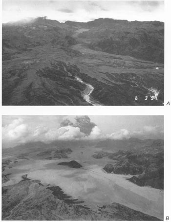
River valley filled in by pyroclastic flows from 1991 eruption of Mt. Pinatubo. Aerial views of Maloma and Marella River valleys comparing preeruption terrain (A) and posteruption terrain with fill of pyroclastic-flow deposits (B). Orientation of both views is northeast toward Mount Pinatubo, but B was taken from a position slightly east of and at higher altitude than that of A. Note hill surrounded by pyroclastic-flow deposits near center of B and compare with A. Main (east fork) channel of Marella River to east (right) of knob has been filled to a depth of about 200 m.
Both photographs by R.P. Hoblitt; A, June 3, 1991; B, June 23, 1991.)
This image is in the
public domain in the United States because it only contains materials that originally came from the
United States Geological Survey, an agency of the
United States Department of the Interior. For more information, see
the official USGS copyright policy.
|
File history
Click on a date/time to view the file as it appeared at that time.
| Date/Time | Thumbnail | Dimensions | User | Comment | |
|---|---|---|---|---|---|
| current | 10:08, 8 March 2006 |
| 350 × 454 (23 KB) | Magalhães | River valley filled in by pyroclastic flows from 1991 eruption of Mt. Pinatubo. Source: [http://pubs.usgs.gov/pinatubo/wescott/fig2.jpg Fig.2] on [http://pubs.usgs.gov/pinatubo/wescott] {{PD-USGov-Interior-USGS}} Mount Pinatubo |
File usage
Global file usage
The following other wikis use this file:
- Usage on bg.wikipedia.org
- Usage on bn.wikipedia.org
- Usage on el.wikipedia.org
- Usage on en.wikibooks.org
- Usage on es.wikipedia.org
- Usage on fi.wikipedia.org
- Usage on fr.wikipedia.org
- Usage on he.wikipedia.org
- Usage on it.wikipedia.org
- Usage on nl.wikipedia.org
- Usage on ru.wikipedia.org
- Usage on sk.wikipedia.org
- Usage on sl.wikipedia.org
- Usage on tl.wikipedia.org
- Usage on tr.wikipedia.org
- Usage on uk.wikipedia.org