PhotosLocation

This is a file from the Wikimedia Commons
From Wikipedia, the free encyclopedia

Original file(6,955 × 6,905 pixels, file size: 8.59 MB, MIME type: image/jpeg)

Summary

Description
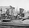
English: Richmond, Virginia Crippled locomotive, Richmond & Petersburg Railroad depot.
Date
Source
This image is available from the United States Library of Congress's Prints and Photographs division
under the digital ID cwpb.02705.
This tag does not indicate the copyright status of the attached work. A normal copyright tag is still required. See Commons:Licensing.

العربية  беларуская (тарашкевіца)  বাংলা  čeština  Deutsch  English  español  فارسی  suomi  français  galego  עברית  magyar  Bahasa Indonesia  italiano  日本語  lietuvių  македонски  മലയാളം  Nederlands  polski  português  português do Brasil  română  русский  sicilianu  slovenčina  slovenščina  Türkçe  українська  简体中文  繁體中文  +/−

Author Unknown authorUnknown author
Camera location 37° 32′ 11.53″ N, 77° 26′ 23.94″ W  Kartographer map based on OpenStreetMap.View this and other nearby images on: OpenStreetMap info

Licensing

Public domain

This work is in the public domain in its country of origin and other countries and areas where the copyright term is the author's life plus 70 years or fewer.


You must also include a United States public domain tag to indicate why this work is in the public domain in the United States. Note that a few countries have copyright terms longer than 70 years: Mexico has 100 years, Jamaica has 95 years, Colombia has 80 years, and Guatemala and Samoa have 75 years. This image may not be in the public domain in these countries, which moreover do not implement the rule of the shorter term. Honduras has a general copyright term of 75 years, but it does implement the rule of the shorter term. Copyright may extend on works created by French who died for France in World War II ( more information), Russians who served in the Eastern Front of World War II (known as the Great Patriotic War in Russia) and posthumously rehabilitated victims of Soviet repressions ( more information).

Information (Geography)

Captions

Add a one-line explanation of what this file represents

Items portrayed in this file

depicts

37°32'11.526"N, 77°26'23.939"W

File history

Click on a date/time to view the file as it appeared at that time.

Date/TimeThumbnailDimensionsUserComment
current 16:53, 16 August 2013 Thumbnail for version as of 16:53, 16 August 20136,955 × 6,905 (8.59 MB)Ras67high resolution
18:43, 29 January 2009 Thumbnail for version as of 18:43, 29 January 2009594 × 582 (229 KB)Lieseladjust & cleaning
18:40, 29 January 2009 Thumbnail for version as of 18:40, 29 January 2009594 × 582 (229 KB)Lieseladjust & cleaninga
18:25, 20 July 2007 Thumbnail for version as of 18:25, 20 July 2007619 × 640 (101 KB)Edmund Ferman
The following pages on the English Wikipedia use this file (pages on other projects are not listed):

Global file usage

The following other wikis use this file:

Metadata