
Size of this preview:
800 × 450 pixels. Other resolutions:
320 × 180 pixels |
640 × 360 pixels |
1,024 × 576 pixels |
1,280 × 720 pixels |
3,264 × 1,836 pixels.
Original file (3,264 × 1,836 pixels, file size: 3.07 MB, MIME type: image/jpeg)
| This is a file from the
Wikimedia Commons. Information from its
description page there is shown below. Commons is a freely licensed media file repository. You can help. |
.jpg)
Summary
| Description |
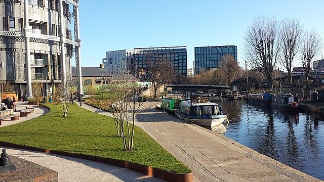
English: Repurposed gas holders and canal locks at Kings Cross. On the northern part of Kings Cross railway lands, three gasholders alongside the Regents Canal have been repurposed. Two, including the one seen here, have had new apartment blocks built in them. The third has been turned into a pocket park. Behind the green fence is the, as yet unfinished, Coal Drops Yard retail development, with a new canal bridge beyond St Pancras Lock. The modern office buildings behind are around St Pancras Square, and include the new Google UK HQ. For a reciprocal view, see
File:Repurposed gas holders and canal locks at Kings Cross (geograph 5691907).jpg. |
| Date | |
| Source | From geograph.org.uk |
| Author | Chris Wood |
| Permission ( Reusing this file) |
Creative Commons Attribution Share-alike license 2.0 |
| Attribution ( required by the license) | Chris Wood / Repurposed gas holders and canal locks at Kings Cross / |
.jpg)
| Camera location | | View this and other nearby images on: OpenStreetMap |
|
|---|
.jpg¶ms=051.536810_N_-000.128161_E_globe:Earth_type:camera_source:geograph-osgb36(TQ29928365)_heading:157.00&language=en)
| Object location | | View this and other nearby images on: OpenStreetMap |
|
|---|
.jpg¶ms=051.535720_N_-000.127630_E_globe:Earth_class:object_type:object_source:geograph-osgb36(TQ29968353)_heading:157.00&language=en)
Licensing

|
This image was taken from the
Geograph project collection. See
this photograph's page on the Geograph website for the photographer's contact details. The copyright on this image is owned by Chris Wood and is licensed for reuse under the
Creative Commons Attribution-ShareAlike 2.0 license.
|
This file is licensed under the
Creative Commons
Attribution-Share Alike 2.0 Generic license.
Attribution: Chris Wood
- You are free:
- to share – to copy, distribute and transmit the work
- to remix – to adapt the work
- Under the following conditions:
- attribution – You must give appropriate credit, provide a link to the license, and indicate if changes were made. You may do so in any reasonable manner, but not in any way that suggests the licensor endorses you or your use.
- share alike – If you remix, transform, or build upon the material, you must distribute your contributions under the same or compatible license as the original.
File history
Click on a date/time to view the file as it appeared at that time.
| Date/Time | Thumbnail | Dimensions | User | Comment | |
|---|---|---|---|---|---|
| current | 14:17, 26 February 2018 |
| 3,264 × 1,836 (3.07 MB) | Chris j wood | Transferred from geograph.co.uk using [https://tools.wmflabs.org/geograph2commons/ geograph2commons] |
File usage
The following pages on the English Wikipedia use this file (pages on other projects are not listed):
.jpg)