Size of this preview:
585 × 599 pixels. Other resolutions:
234 × 240 pixels |
469 × 480 pixels |
1,000 × 1,024 pixels.
Original file (1,000 × 1,024 pixels, file size: 1.73 MB, MIME type: image/png)
| This is a file from the
Wikimedia Commons. Information from its
description page there is shown below. Commons is a freely licensed media file repository. You can help. |
Summary
| Description |
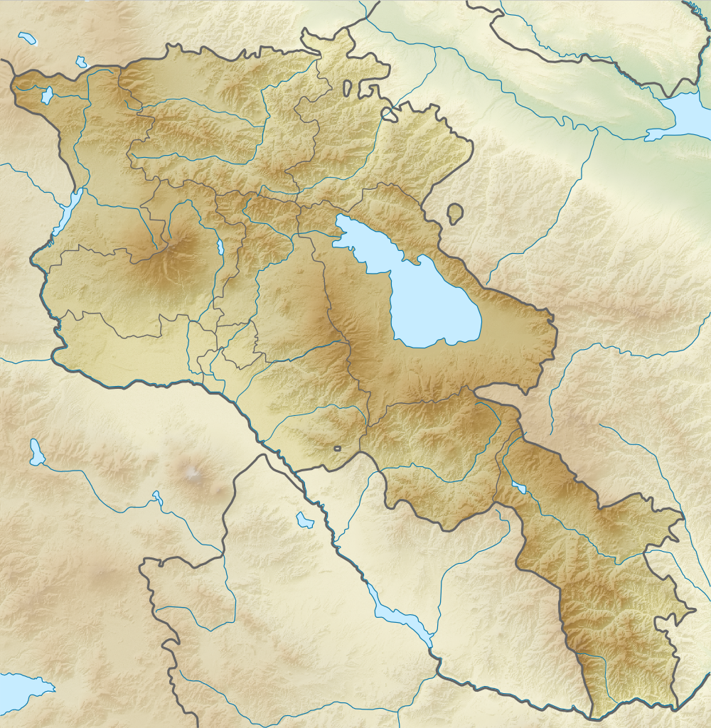
English: Relief map of
Armenia. Equirectangular projection, N/S stretching 130 %. Geographic limits of the map:
Français : Carte topographique de l'
Arménie. Projection cylindrique équidistante, avec étirement nord-sud de 130%.
|
| Date | |
| Source | |
| Author |
|
| Permission ( Reusing this file) |
This file is licensed under the
Creative Commons
Attribution-Share Alike 3.0 Unported license.
|
File history
Click on a date/time to view the file as it appeared at that time.
| Date/Time | Thumbnail | Dimensions | User | Comment | |
|---|---|---|---|---|---|
| current | 18:21, 22 February 2014 |
| 1,000 × 1,024 (1.73 MB) | A2D2 | No unilateral changes. International borders are used. Please create additional svg map. |
| 09:21, 21 February 2014 |
 | 585 × 599 (654 KB) | Հայկ Ափրիկյան | Added Artsakh. | |
| 19:49, 5 April 2012 |
 | 1,000 × 1,024 (1.73 MB) | Sémhur | Adding few rivers : Dzoraget, Aghstafa, Azat, Vedi and Megri | |
| 19:36, 26 August 2010 |
 | 1,000 × 1,024 (1.73 MB) | Виктор В | == {{int:filedesc}} == {{Information |Description={{en|Relief map of Armenia}} Equirectangular projection, N/S stretching 130 %. Geographic limits of the map: * N: 41.4° N * S: 38.8° N * W: 43.4° E * E: 46.7° E |Source=*[[:File:Armenia |
File usage
The following pages on the English Wikipedia use this file (pages on other projects are not listed):
- 1679 Armenia earthquake
- 1931 Zangezur earthquake
- 1988 Armenian earthquake
- 893 Dvin earthquake
- Aghjots Vank
- Akhtala Monastery
- Akhurian Reservoir
- Akhuryan (river)
- Ara (mountain)
- Aramazd mountains
- Areni-1 cave
- Areni Church
- Arevik National Park
- Azhdahak (volcano)
- Battle of Artaxata
- Battle of Garni
- Byurakan Observatory
- Dar-Alages
- Dilijan National Park
- Erebuni State Reserve
- Garni Temple
- Gazanaler
- Geghard
- Gladzor
- Godedzor
- Goshavank
- Haghartsin Monastery
- Haghpat Monastery
- Harichavank Monastery
- Hovhannavank
- Javakheti Range
- Kecharis Monastery
- Khosrov Forest State Reserve
- Khustup
- Kirants Monastery
- Kobayr monastery
- Lake Akna (Kotayk)
- Lake Arpi
- Lake Arpi National Park
- Lake Ayger
- Lake Kari
- Lake Lessing
- Lake Parz
- Lake Sev
- Lake Sevan
- List of fossiliferous stratigraphic units in Armenia
- Matosavank
- Meghri Dam
- Mordechai Navi Synagogue
- Mount Achkasar
- Mount Aragats
- Mount Kaputjugh
- Noravank
- Orgov Radio-Optical Telescope
- Porak
- Proshaberd
- Saghmosavank
- Sanahin Monastery
- Sevan National Park
- Sevanavank
- Shikahogh State Reserve
- St Gregory of Tigran Honents
- Tanahat Monastery
- Tandzut (river)
- Teishebaini
- Tejharuyk Monastery
- Tskhouk-Karckar
- Vanadzor (river)
- Vorotan (river)
- Yerevan
- Yerevan Lake
- User:Falcaorib
- User:Ty654/List of earthquakes from 1985-1989 exceeding magnitude 6+
- Module:Location map/data/Armenia
- Module:Location map/data/Armenia/doc
Global file usage
The following other wikis use this file:
- Usage on ar.wikipedia.org
- Usage on ast.wikipedia.org
- Usage on av.wikipedia.org
- Usage on azb.wikipedia.org
- Usage on az.wikipedia.org
- Ağçala dağı
- Göyçə gölü
- Şablon:Yer xəritəsi Ermənistan
- Zəngiçay
- Alagöz dağı
- Loru çökəkliyi
- Ləlvar dağı
- Qazangöl (Ermənistan)
- Şəki şəlaləsi
- Dilijan Milli Parkı
- Göyçə yarımadası
- Ardanış yarımadası
- Goravan səhrası
- Tej-əhməd dağı
- Kari gölü
- Arpi gölü
- Şikahoğ Dövlət Təbiət Qoruğu
- Erebuni Dövlət Təbiət Qoruğu
- Mehri SES
- Göyçə-Zəngi kaskadı
- İrəvan Dəmiryol Stansiyası
- Gümrü Dəmiryol Stansiyası
- Xosrov Dövlət Təbiət Qoruğu
- Göyçə Milli Parkı
- İrəvan Botanika Bağı
- Ağrı vadisi
- Şərqi Göyçə silsiləsi
- Nərədüz burnu
- Balıqlı (göl)
- Apaklu
- Qarnıyarıq dağı
- Bərgüşad kaskadı
- Bərgüşad silsiləsi
- Qılıncdağ
- Abaran (yaylaq)
- Ajdaak vulkanı
- Geğam silsiləsi
- Qanlı göl (Göyçə)
- Axuryan su anbarı
- Lecan dağı
- Gərni dərəsi
- İrəvan zəlzələsi (1679)
- Usage on ba.wikipedia.org
View more global usage of this file.