Size of this preview:
800 × 351 pixels. Other resolutions:
320 × 140 pixels |
640 × 281 pixels |
1,425 × 625 pixels.
Original file (1,425 × 625 pixels, file size: 66 KB, MIME type: image/png)
| This is a file from the
Wikimedia Commons. Information from its
description page there is shown below. Commons is a freely licensed media file repository. You can help. |
Summary
| Description |
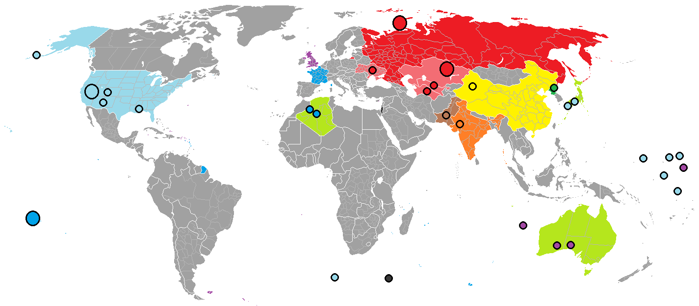
English: Red: Russia/Soviet Union; blue: France; light blue: United States; purple: United Kingdom.
Over 2,000 nuclear explosions have been conducted, in over a dozen different sites around the world. Yellow China, orange India, brown Pakistan, green North Korea and light green (territories exposed to nuclear bombs). The Black dot indicates the location of the Vela Incident |
| Date | |
| Source |
in Paint |
| Author | Palli3000 |

|
This map image could be re-created using
vector graphics as an
SVG file. This has several advantages; see
Commons:Media for cleanup for more information. If an SVG form of this image is available, please upload it and afterwards replace this template with
{{
vector version available|new image name}}
.
It is recommended to name the SVG file “Rael Nuclear use locations world map.svg”—then the template Vector version available (or Vva) does not need the new image name parameter. |
Licensing
I, the copyright holder of this work, hereby publish it under the following licenses:

|
Permission is granted to copy, distribute and/or modify this document under the terms of the GNU Free Documentation License, Version 1.2 or any later version published by the Free Software Foundation; with no Invariant Sections, no Front-Cover Texts, and no Back-Cover Texts. A copy of the license is included in the section entitled GNU Free Documentation License. |
This file is licensed under the
Creative Commons
Attribution-Share Alike 3.0 Unported license.
- You are free:
- to share – to copy, distribute and transmit the work
- to remix – to adapt the work
- Under the following conditions:
- attribution – You must give appropriate credit, provide a link to the license, and indicate if changes were made. You may do so in any reasonable manner, but not in any way that suggests the licensor endorses you or your use.
- share alike – If you remix, transform, or build upon the material, you must distribute your contributions under the same or compatible license as the original.
You may select the license of your choice.
File history
Click on a date/time to view the file as it appeared at that time.
| Date/Time | Thumbnail | Dimensions | User | Comment | |
|---|---|---|---|---|---|
| current | 09:19, 23 March 2018 |
| 1,425 × 625 (66 KB) | Maphobbyist | South Sudan border |
| 18:26, 29 March 2017 |
 | 1,425 × 625 (59 KB) | Tiger7253 | Colouring in Andaman and Nicobar Islands and Lakshadweep for India - original uploader forgot to shade the grey islands in | |
| 13:27, 25 July 2012 |
 | 1,425 × 625 (85 KB) | Palli3000 | {{subst:Upload marker added by en.wp UW}} {{Information |Description = {{en|Red Russia/Soviet Union, blue France, light blue United States, Over 2,000 nuclear explosions have been conducted, in over a dozen different sites around the world. violet Bri... |
File usage
The following pages on the English Wikipedia use this file (pages on other projects are not listed):
Global file usage
The following other wikis use this file:
- Usage on ar.wikipedia.org
- Usage on da.wikipedia.org
- Usage on es.wikipedia.org
- Usage on fr.wikipedia.org
- Usage on hr.wikipedia.org
- Usage on it.wikipedia.org
- Usage on ja.wikipedia.org
- Usage on sh.wikipedia.org
- Usage on sr.wikipedia.org
- Usage on th.wikipedia.org
- Usage on uz.wikipedia.org
- Usage on vi.wikipedia.org