Original file (2,816 × 2,112 pixels, file size: 2.72 MB, MIME type: image/jpeg)
| This is a file from the
Wikimedia Commons. Information from its
description page there is shown below. Commons is a freely licensed media file repository. You can help. |
.jpg)
Summary
| Description |
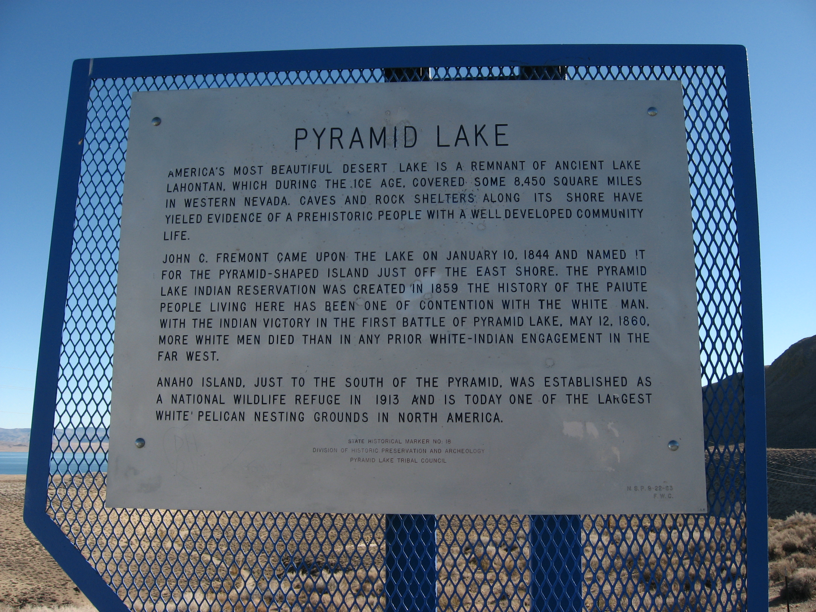
America's most beautiful desert lake is a remnant of ancient Lake Lahontan, which during the Ice Age covered over 8,000 square miles. Caves along its shores have revealed a prehistoric people with a well-developed community life. John C. Fremont discovered the lake on January 10, 1844, and named it for the pyramid-shaped island it contains. From 1844 to the 1860's, the lake's history is an account of native people in contention with the white invasion of northwestern Nevada. With the Indian victory in the first battle of Pyramid Lake, May 12, 1860, more white men died than in any prior White-Indian engagement in the far west. The Pyramid Lake Reservation was set aside for the Indians in 1859. The unusual calcium carbonate Tufa formations along the lake shore are formed by algae, by precipitation from hot springs, from concentration during drier periods, and from wave-action shoreline deposits. The 41-pound world record size cutthroat trout was taken from Pyramid Lake, in 1925, by Johnny Skimmerhorn, a Paiute Indian. The lake is the home of the Cui-ui, a peculiar lakesucker now found nowhere else in the world. Anaho Island, a national wildlife refuge, is probably the largest white pelican nesting colony in North America. www.nevada-landmarks.com/wa/shl18.htm |
| Date | |
| Source | Pyramid Lake, Nevada Historical Marker No. 18, Near Sutcliff, Nevada |
| Author | Ken Lund from Reno, Nevada, USA |
| Camera location |
| View this and other nearby images on: OpenStreetMap |
|
|---|
.jpg¶ms=039.902897_N_-119.565775_E_globe:Earth_type:camera_source:Flickr_&language=en)
Licensing
- You are free:
- to share – to copy, distribute and transmit the work
- to remix – to adapt the work
- Under the following conditions:
- attribution – You must give appropriate credit, provide a link to the license, and indicate if changes were made. You may do so in any reasonable manner, but not in any way that suggests the licensor endorses you or your use.
- share alike – If you remix, transform, or build upon the material, you must distribute your contributions under the same or compatible license as the original.
| This image was originally posted to Flickr by Ken Lund at https://flickr.com/photos/75683070@N00/4134266029. It was reviewed on 5 December 2015 by FlickreviewR and was confirmed to be licensed under the terms of the cc-by-sa-2.0. |
File history
Click on a date/time to view the file as it appeared at that time.
| Date/Time | Thumbnail | Dimensions | User | Comment | |
|---|---|---|---|---|---|
| current | 21:56, 5 December 2015 |
| 2,816 × 2,112 (2.72 MB) | INeverCry | Transferred from Flickr via Flickr2Commons |
.jpg)